
GIS Business Plan
Geographic Information Services Unit
April 2020

ODOT Geographic Information Services Unit GIS Business Plan 2
Document prepared by Timmons Group.
Reviewed and endorsed by Oregon Department of Transportation (ODOT) Geographic
Information Services Unit (GIS Unit) GIS Business Plan Project Team.
Approval by ODOT GIS Unit April 2020.
GIS Business Plan Project Team
Chris Wright – ODOT
Brett Juul - ODOT
Phil Smith - ODOT
Chad Brady - ODOT
Chad Crockett - ODOT
Andy Fox – Timmons Group
Tim Sheldon – Timmons Group
Sean Diehl – Timmons Group
Mike Sullivan – Timmons Group

ODOT Geographic Information Services Unit GIS Business Plan 3
Contents
I. Executive Summary ................................................................................................ 4
II. Introduction ............................................................................................................. 7
III. Approach .................................................................................................................. 9
IV. Findings .................................................................................................................. 13
V. Performance Management .................................................................................. 31
VI. GIS Strategy & Implementation ........................................................................ 37
VII. Recommendations ................................................................................................ 41
VIII. Document Revision History ............................................................................... 49
IX. Appendix A: GIS Unit Technology and Tools
Portfolio .................................................................................................................. 50
X. Appendix B: Comprehensive
Recommendations ................................................................................................ 58
XI. Appendix C: Slimgim-T Reference ................................................................... 79
XII. Appendix D: Terms and Acronyms ................................................................... 86
XIII. Appendix E: Tables and Figures ........................................................................ 91

ODOT Geographic Information Services Unit GIS Business Plan 4
Executive Summary
Plan Purpose
The purpose of this GIS Business Plan is to provide the Geographic Information Services
Unit (GIS Unit) of the Oregon Department of Transportation (ODOT) with common and
communicated direction and guidance for the next five (5) years to improve the usage of
technology and data as well as the practices of people.
Plan Background
This plan is built on the success of previous plans
1
and is informed by a series of
stakeholder engagements, peer state examinations, literature reviews, present condition
assessments, and outlooks on industry trends (see Approach section below).
GIS Unit Overview
The GIS Unit serves the Oregon
Department of Transportation
by effectively providing
geographic information
products and services through
the development of spatially-
enabled applications,
databases, mapping products,
analysis, education,
consulting and technical
support.
1
See ODOT Strategic Plan, ODOT Strategic Data Business Plan, 2008 GIS Unit Strategic Plan.
Figure 2: GIS Unit Team Photo 2020
Figure 1: Policy, Data and Analysis Division Org Chart

ODOT Geographic Information Services Unit GIS Business Plan 5
Key Concepts of the Plan
The following are key concepts of this business plan. Each section represents multiple
activities detailed in the plan which together constitute overall focus area designed to
continue to grow the capabilities and services of the GIS Unit to meet stakeholder needs
(see Recommendations section).
GIS Supports ODOT Strategic Priorities
The priorities of this business plan align with the strategic goals of ODOT. The goals and
objectives of the ODOT Strategic Business Plan and ODOT Strategic Data Business Plan
were considered throughout the planning process. Central to ODOT strategic goals is
making informed decisions towards a common goal. As this business plan is
implemented, the GIS Unit will help provide the technology, tools, data, and skills to
develop the right information for ODOT staff and stakeholders to make informed
decisions.
Performance Management of GIS
Performance management is rooted in the goals and objectives of an organization. When
these goals and objectives are aligned with well-defined methodologies that are
automated as much as possible, the opportunity for success is maximized. This plan both
establishes and builds upon existing performance management practices in the areas of
staff performance, stakeholder input & outreach, service requests, technical system
performance, GIS production, GIS project effectiveness and benefit, and the continuing
use of a capability maturity model (CMM). These recommendations were informed by a
nation-wide questionnaire (with assistance from FHWA) of DOT GIS professionals about
their GIS performance management practices.
GIS Outreach
Expressed time and time again throughout the development of this business plan via
survey respondents and one-on-one interviews with ODOT GIS Unit staff, the need for
outreach is a key component for increased success of the GIS Unit.
Survey respondents commented that the GIS Unit communicate and coordinate with
them. However, many also reported a need for service offerings which are already
offered by the GIS Unit, they simply aren’t aware that the requested offerings already
exist.
Stakeholder Survey Respondent: “I am still not familiar with what types of maps and geographic data I
have access to; if I were to know that then I would know whether any of the tools would benefit my
work.”
Stakeholder Survey Respondent: “It[s] not for a lack of help with the GIS unit. They are very helpful. The
limitations are with the tool and the source data.”

ODOT Geographic Information Services Unit GIS Business Plan 6
GIS Needs Discovery
There are many examples of “needs discovery initiatives” in the plan that follows,
ranging from evaluating the need for additional positions with new roles and
responsibilities (such as GIS Business Analysts and Project Managers) to evaluating the
implementation of new tools and technologies. A common theme with each initiative is
that they are part of a critical path towards a higher functioning, more mature
organizational GIS that continues to meet the needs of ODOT and its stakeholders. The
GIS Unit will leverage existing frameworks and processes such as the Decisions and
Information Needs Identification Tool for understanding and prioritizing data and tool
needs in ways that align with other decision-making methods for data and technology
across the agency.
GIS with Purpose
Two shifting paradigms are changing GIS fundamentally. The shifts are affecting GIS as
a discipline and specifically are impacting GIS for transportation including at ODOT.
1) First, GIS is becoming application centric with business-driven workflows that
leverage GIS to perform tasks in ways in which the user is often not fully even
aware. Direct interfacing with a GIS is increasingly possible and requested with
technology advances and data improvements typically in the form of best practice
implementations in enterprise data stores.
2) Second, the adoption and use of GIS is becoming a core skill in education and the
workplace. More and more workers have GIS skills and are bringing them to non-
GIS positions. Additionally, GIS is more frequently being an included part of our
expected ODOT workflows.
All these changes can be viewed as positive shifts. However, the challenge to the GIS Unit
is to account for and provide the needed tools, technologies, and training related to these
shifting paradigms. In short, GIS is becoming decentralized while the use is increasing
significantly. This business plan specifically acknowledges these shifts and provides
planned activities to guide GIS programs forward into these newer waters.

ODOT Geographic Information Services Unit GIS Business Plan 7
Introduction
Purpose
The Oregon Department of Transportation has a history of GIS planning, having created
a GIS Strategic Plan in 2006, followed by a GIS Implementation Plan the same year. In
2008, the GIS Strategic Plan was updated based on activities of the GIS Implementation
Plan and has served its purpose; however, as the needs and considerations have
substantially changed, a new and fresh effort is practical and needed. The purpose of this
GIS Business Plan is to provide a common and communicated direction and guidance for
the next five (5) years to improve the usage of technology and data as well as the practice
of ODOT staff and stakeholders.
Approach and Findings
The GIS Unit serves ODOT by providing geographic information products and services
through the development of spatially enabled applications, databases, mapping products,
analysis, education, consulting, and technical support.
This plan is informed by a series of stakeholder engagements, peer state examinations,
literature reviews, present condition assessments, and outlooks on industry trends (see
Approach section) to gain an in-depth understanding of the needs and uses of geographic
information products and services of the agency. Findings of these engagements were
recorded in a series of support documents (see Findings section).
Recommendations
In the Recommendations section, top recommendations are organized by category to give
the GIS Unit manageable and achievable areas to tackle in a five-year plan. Quick wins
are identified where swift efforts could produce immediate tangible results. A
comprehensive collection of all recommendations developed as a result of these planning
efforts is provided in Appendix B Comprehensive Recommendations.

ODOT Geographic Information Services Unit GIS Business Plan 8
Implementation
This business plan provides the foundation for implementation planning for GIS
programs of the GIS Unit (see GIS Strategy & Implementation) by identifying key needs
and prioritizing recommendations toward addressing them.
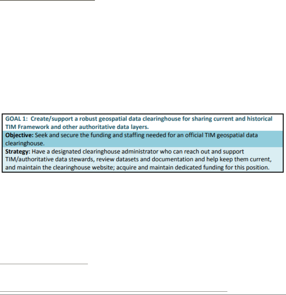
Plan Framework
The ODOT Strategic Data Business
Plan (SDBP) process led to the
development of a strategic
framework. The GIS Unit Business
Plan largely follows this framework
with a mission and vision followed
by goals. Each goal has more
specific sub-goals that relate to
objectives. The activities in this GIS
Unit plan are equivalent to
strategies in this framework. Each
activity has a specific objective and is aligned to GIS Unit goals.
Document Terms and Acronyms
We have done our best to avoid using subject specific language (jargon) and acronyms in
this document. We use jargon only when it is necessary to convey specific meaning and
have defined terms in Appendix A and/or in context where appropriate. We have used
acronyms sparingly, replacing words only when they are often repeated. Please reference
Appendix D for further details on terms or acronyms.
GIS Business Plan
GIS Strategy
Mission, Vision, Goals
GIS Planning
Objectives, Activities
Activities Schedule
Performance Management Framework
GIS Implementation Plan
GIS CapabilityMaturity Model
Training Plan
Stakeholder Communication Plan
Inter-agency Communication Plan
Performance Management Plan
Needs Assessment Plan(s)
Data Development Plan
Infrastructure Plan
Application Dev.& Support Plan
Program
GIS Work Plan
Budget
GIS Annual Needs Assessment Update
Stakeholder Outreach
Inter-agency data sharing
Technology & Tool Proliferation
GIS Data Development
GIS Infrastructure
GIS Applications
Mapping
Training
Figure 3: SDBP Strategic Framework Elements adopted by GIS Business Plan

ODOT Geographic Information Services Unit GIS Business Plan 9
Approach
This project engaged a significant cross-section of ODOT participants, stakeholders, and
peers including GIS Unit staff, IT, executive leadership, stakeholder ODOT committees,
GIS and geospatial data users ODOT-wide, and peer state GIS staff.
The result of this ODOT engagement generated several information gathering and review
documents that inform this plan. Additionally, these documents provide more subject
specific detail for the GIS Unit to implement identified needs and opportunities of this
plan.
1
Project Kickoff and ODOT GIS Unit Background Review
2
Literature Review of GIS Planning for Public Agencies
3
Summary of Stakeholder Findings: Peer State Transportation
Agency GIS Comparison & ODOT Stakeholder Engagement
(Survey & Interviews)
4
GIS Tools and Technology Audit
5
Workforce Development: Skill Competencies & Training
Strategies
6
GIS Performance Management
7
GIS Unit Business Plan

ODOT Geographic Information Services Unit GIS Business Plan 10
Project Kickoff and Background Review
An initial Project kickoff meeting (web-based) was held with ODOT key project
leadership for first introductions, high-level project overview, discussion of how the
project would be executed and conducted, to sync calendars and schedule recurring
project meetings, and review the project schedule. A formal project kickoff (on-site) was
also held with ODOT Project team and stakeholders identified by ODOT for a high-level
overview of the project scope, schedule, and to conduct initial roundtable discussions
about the plan.
ODOT possesses extensive background documentation about its current GIS
organization, staffing, training, data, software, policies and procedures. Review of this
background documentation provided a valuable information foundation for subsequent
project tasks.
Literature Review of GIS Planning for Public Agencies
The purpose of the literature review is to examine other perspectives, topic areas,
strategies, and/or methods for strategic and business planning for GIS by other public
(specifically transportation) agencies/departments to provide ODOT with broader
contexts from which to proceed for the GIS Unit Business Plan.
Key word searches executed in a variety of web search engines and on FHWA TRB
2
were
used to find both anticipated and unanticipated documents for review. Documents for
GIS/Geospatial Strategic and Business Plans were reviewed from state DOTs, other
agencies (state and federal), as well as state-wide plans.
Operating Questions:
• What is the role and benefit of a GIS Business Plan for transportation agencies?
• How do transportation agencies plan for GIS?
• What are characteristics and examples of good and bad GIS planning?
Summary of Stakeholder Findings: Peer State Transportation Agency GIS Comparison
& ODOT Stakeholder Engagement (Survey & Interviews)
Peer State Transportation Agency GIS Comparison
A comparative benchmarking was conducted by evaluating and interviewing three (3)
pre-approved DOTs of similar size and complexity (Washington, Iowa, and Georgia). The
goal of this comparative benchmarking was to gain an understanding of ODOT’s relative
state of system including such areas as technology stacks, organizational alignments,
organizational structure and staffing, governance models, related scripting and
programming tools/technologies, and data storage.
2
Federal Highway Administration, Transportation Research Board.
http://www.trb.org/Main/Home.aspx.

ODOT Geographic Information Services Unit GIS Business Plan 11
A gap analysis, as a qualitative study, between ODOT and the three (3) benchmarked
DOTs was then conducted. Available published materials from the peer DOTs were used
for the analysis with some materials furnished by DOT GIS managers
by request for this
study where additional information was needed. Interviews of enterprise GIS leadership
from each peer state were then conducted (see summary of findings in next section).
ODOT Stakeholder Engagement (Survey & Interviews)
The purpose of the ODOT stakeholder surveys and interviews was to gather firsthand
knowledge about ODOT’s current GIS – what is working, and what could use
enhancement. The purpose of the survey was to collect information from the participants
that may take time to research and compile, and therefore cannot generally be collected
conveniently (or completely) during on-site interviews. Following the review and
analysis of the online survey results, meetings were held with ODOT staff representing
the range of GIS users to collect information and provide a knowledge transfer
opportunity to participants. The interviews provided a forum for information exchange
between GIS stakeholders and Timmons Group. Stakeholders had a chance to expand
on survey results and to learn more about how GIS is successfully implemented and used
by their peers in other states. Group interview sessions were well attended, and attendee
participation in the discussions was very good.
GIS Tools and Technology Audit
The purpose of the GIS Technology Audit was to develop an inventory of existing GIS
tools and technologies across the agency to clearly understand and document existing
maintenance responsibilities and identify any gaps.
Preliminary interviews were conducted on-site with ODOT GIS Unit staff July 16, 2019
and August 12-14, 2019 during which discovery on a variety of topics was conducted
including GIS and related tools and technologies. An in-depth ODOT website review was
subsequently conducted to review previously identified tools and technologies and note
any newly discovered items for further discussions. An ODOT- wide survey captured a
variety of off-the-cuff comments regarding tools and technology which were carefully
noted and consolidated for follow up with the GIS Unit core team. In depth on-site
stakeholder interviews were conducted September 23-25, 2019 during which time the
identified tech and tools from previous discovery efforts were discussed with SMEs and
other knowledgeable staff.
Workforce Development: Skill Competencies & Training Strategies
The purpose of the Workforce Development document was to provide additional and
specific guidance in the pursuit of the investment in a critical organizational resource, its
staff. The approach followed a logic stream of why and how workforce development is
critical to success:

ODOT Geographic Information Services Unit GIS Business Plan 12
1. Organizations grow and improve on the abilities and engagement of their
workforce.
2. Behind the best processes are the workforces that developed, implemented, and
consistently follow them.
3. An organization can only bring in the best technology when their workforce can
recognize it among the sea of options, understand its potential, deploy it to their
colleagues, and maximize its potential.
In short, any business plan, particularly one involving information technologies, must
pay critical attention to their workforce, both stewards and users. The approach to pay
“critical attention” to workforce development involved:
• On-site interviews with fifteen (15) ODOT GIS Unit staff and management gained
their perspectives on job tasks, competencies, and expectations of staffed positions.
• A review of organizational structure, job roles, and job skill levels for ODOT GIS
Unit was conducted by reviewing staffing documentation: organizational charts,
position descriptions, Performance Management Frameworks (“PMFs”),
Capability Maturity Models, Oregon DOT business plans, and previous job
announcements.
• Alignment of Workforce Development goals, objectives, and actions among
business initiatives (providing a broader framework for the GIS Unit Business
Plan) were mapped.
• Recommendations for developing a training plan, skill competency alignment,
and organizational structure configuration were made.
GIS Performance Management
The purpose of the GIS Performance Management document was to provide additional,
specific guidance in the pursuit of identifying performance measures for the agency along
with the data, methods, tools by and with which to make assessments.
GIS leadership in twenty-three (23) state DOT’s were identified and reached out to by
way of the AASHTO identified DOT GIS-T contacts list via an emailed request for
information. Responses were invited via email or phone interview, if preferred. A second
email to all 50 states was sent on behalf of ODOT by FHWA with the same questions to
encourage responses.
Responses were received from the DOTs of Connecticut, South Carolina, Pennsylvania,
Ohio, Georgia, Alaska, New York, and Wisconsin. Their complete responses were
captured in an appendix and summarized in the document. The GIS-related performance
management concepts/measures they shared are discussed in reference to respective
sections of the document.

ODOT Geographic Information Services Unit GIS Business Plan 13
Findings
This section briefly summarizes and highlights some of the findings from the
supporting engagement activities, as outlined in the Approach section above, that
inform this business plan.
Literature Review
The reviewed literature provided background, concepts, and ideas from a variety of GIS
planning document sources to inform the GIS Unit Business Plan that were summarized
into three (3) categories:
• Examination of the Current State
• Potential and Obstacles
• Strategy and Implementation
Examination of the Current State
A summary or examination of the current state of GIS as a part of a business plan (or in
its preparation) is a common element of documents. Most plans provide history to give
context for the direction and vision provided by the plan. In its absence, a reader (such as
executive leadership or the public) would have nothing upon which to tether the logic or
reasoning behind the direction.
Sections discussing history vary in length and detail; however, many focus on the
successes and positives, spending little time or attention on areas of known deficiencies,
concerns or struggles. The USDOT’s GIS Strategic Plan
3
is a good example of a more
dispassionate accounting of the GIS agency’s responsibilities and it includes an
interesting evaluation of full time employee (FTE) staffing levels (current vs optimal
numbers) necessary to meet strategic goals (see Workforce Development section within
this Findings section below).
In an update to their 2008 Strategic Plan, Maine DOT included updated appendices
4
from
their 2002 GIS Strategic plan that included a list of “Pillars”, their component parts, status,
and comments. Though the content is now dated, this organizational/structure concept
from a historical perspective is an effective and efficient way to provide context and status
of programs, initiatives, and projects that is well organized and easily digestible. The GIS
3
USDOT Strategic Plan for FY 2018-2022
https://www.transportation.gov/sites/dot.gov/files/docs/mission/administrations/office-
policy/304866/dot-strategic-planfy2018-2022508.pdf
4
Maine GeoLibrary Board 2008 Strategic Plan Update
https://www.maine.gov/geolib/publications/2009%20Strategic_Plan/ME%20Strategic%20Plan%20Append
ices%20Final%2004-30-09.pdf

ODOT Geographic Information Services Unit GIS Business Plan 14
Unit Tools and Technology Portfolio section of this document benefited from concepts of
the Maine “Pillars” concept.
Addressing various staffing challenges are a common theme among GIS planning
documents including staffing levels (discussed in this section); attracting and retaining
qualified staff (discussed in other sections of this document); and training (discussed in
other sections of this document). Staffing levels and software needs are co-linear
concepts: the amounts of GIS staff, their technical needs, and usage patterns drive
software (and licensing) needs.
The USDOT GIS Plan summarizes by business area (what they call “Mode” and what
are better known as the various composite administrations of the USDOT) the current
number of GIS FTEs
along with an evaluation
of current staffing level
and a corresponding
“optimal staffing level”
needed to meet strategic
goals in a table (right).
This table provides a
very digestible
assessment of current
staffing capabilities,
shortfalls, and position
recruitment activities.
Though the purpose of
this document was not to
assess staffing shortfalls,
this and the
supplemental documents
provide much of the
critical background
information for such as a
next step activity.
Potential and Obstacles
This section examined obstacles to GIS program growth, unequal GIS development
across agencies, and technology trends from reviewed plans of other agencies. Common
obstacles to program growth and vision alignment for the GIS programs include
dedicated and predictable funding and developing performance metrics to track
geospatial Return on Investment (ROI). An inability to track geospatial ROI may hinder
long term security of programmatic funding. Though funding and agency value is not a
Figure 4: GIS-FTE Staffing Evaluation Table (USDOT)
ODOT Geographic Information Services Unit GIS Business Plan 15
current challenge for the GIS Unit, clearer ROI benefits of GIS programs help decision
makers to continue to prioritize them during any challenging budget times.
Unequal GIS development across agencies was consistently attributed to development of
GIS programs in “relative isolation”
5
from business unit to business unit causing
disconnects between GIS budgets, standards, training, data, and capability. The GIS Unit
being a unifying force for GIS at ODOT has a unique challenge to help coordinate,
consolidate, economize, and standardize GIS for the agency. The GIS Unit has potential
to provide the agency with increased ROI through understanding technology trends and
therefore being better situated to implement the best GIS solutions and technology early
in their lifecycles for the most longevity and value.
Strategy and Implementation
The purpose of this section was to provide an overview of a variety of GIS goals and
implementation concepts, communication methods, and strategies. These were gathered
from the agency and business unit level. The key concept here being that the critical step
in between goals and implementation are planned actions which are the focus of a
business plan. Also important is the link or connection between goals, actions, and
objective. Without a clear connection to specific goals, it can become challenging for
decision-makers to communicate the need for requirements, justify budget and actions,
and measure success of those actions against goals.
The Idaho 2016 GIS Strategic Plan offers a good example of aligning goals with
objectives and strategies.
6
Figure 5: Idaho 2016 GIS Strategic Plan: Goal, Objective, Strategy alignment example
The concept of alignment became a core project theme tethering the work of each
engagement activity. Readers may note that all recommendations in this plan have an
objective and are tethered to GIS Unit goals.
6
2016 Idaho GIS Strategic Plan, page 7.
https://gis.idaho.gov/pdf/Standards/_ISDI_StrategicPlan_APPROVED_20161206.pdf

ODOT Geographic Information Services Unit GIS Business Plan 16
The section of the literature review on implementation could be informative for the GIS
Unit in drafting subsequent implementation documents to this business plan. Examples
of projection costing tables, responsibly matrices, timeline Gantt charts, and prioritization
matrices from a variety of sources are provided.
Summary of Stakeholder Findings
The Summary of Stakeholder Findings provides an overview of the findings of
Stakeholder Engagement (Survey & Interviews) and a Peer State Transportation Agency
Comparison.
ODOT Stakeholder Engagement (Survey & Interviews)
In order to help document and assess the current state of GIS at the Agency, input from
was gathered from GIS stakeholders across the organization using an online survey and
focused group interviews. In all, 226 ODOT staff members responded to the survey and
almost 100 key stakeholders were interviewed to gather information about:
• Level, type and frequency of GIS use
• Access to maps and geographic data
• Access to GIS technology and tools
• Access to GIS technical support
• Access to GIS training
• GIS organizational structure and leadership
• GIS culture
• GIS process orientation
• GIS enterprise sustainability
• Thoughts in general about GIS at ODOT
Figure 6 - Summary on GIS survey responses

ODOT Geographic Information Services Unit GIS Business Plan 17
Hundreds of stakeholder comments were documented and analyzed to identify common
themes, GIS requirements and opportunities to enhance GIS at ODOT. Eighty-five (85)
important findings were identified and summarized in the last section of the Summary
of Initial Stakeholder Findings report and included:
1. Access to Information - Enhance Access to Location Based Information
2. Access to GIS Technology - Increase Information Availability
3. Access to GIS Technical Support - Engage and Strengthen Community
4. Access to GIS Training - Promote Use and Adoption of GIS through Establishing
Training Practices for Lifetime Learners
5. GIS Organizational Structure and Leadership - Foster Community for Location-
Based Decisions
6. GIS Organizational Structure and Leadership - Establish Plan for Stewardship and
Administration to Improve Quality & Performance
7. GIS Culture - Refine Norms, Values, and Traditions
8. GIS Process Orientation – Establish Metrics to Evaluate and Monitor the
Effectiveness of GIS
9. GIS Enterprise GIS Sustainability - Formulate Responsible Priorities and Principals
to Guide Technology Change and Implementation
Figure 7 – The level of ODOT GIS stakeholder agreement (in % of survey respondents) with various characteristics of ODOT's
current GIS.

ODOT Geographic Information Services Unit GIS Business Plan 18
Peer State Transportation Agency Comparison
The table below is a brief summary of findings from peer states, by discussed topic, with considerations for the GIS Unit.
Topic
Iowa DOT
Washington DOT
Georgia DOT
ODOT Considerations
GIS Strategic
Planning
No GIS strategic plan.
GIS policy with goals.
No GIS strategic plan.
Last GIS strategic plan from
1990s.
GIS Unit is a leader in this
space.
GIS Assessments
Slimgim-T.
No GIS assessments in use.
No GIS assessments in use.
Continue using Slimgim-T
GIS Data
Governance
Authoritative group owns the
process to institutionalize
governance, but not to dictate
governance.
New effort to reinvigorate GIS
governance. Formed GIS sub-
committees for GIS resourcing
and data governance.
Plan to leverage FHWA pooled
fund study on GIS Data
Governance final report.
Leverage ODOT robust use
and trust of committees
toward GIS governance goals.
GIS Capability
and Investment
Investment self-characterized
as “good.”
Novice to advanced users.
Funding for GIS directly from
business units.
Novice to advanced users.
Enterprise GIS is funded by IT
Division (no bill back).
Novice to advanced users.
Models for GIS investment
vary. Need to support novice
to advanced users is consistent.
Organizational
Structure and
Staff for GIS
Federated: Central GIS; IT
Division; GIS Coordinators
with central and district offices
Centralized: IT Division; GIS &
Roadway Data Team; Planning
Division
Centralized: Office of IT
Applications; Office of
Transportation Data
No structure is perfect. In the
end, GIS will always traverse
many business units.
GIS Data
Stewards
Data publishers are de facto
data stewards.
Business Units responsible.
GIS & Roadway Data team
gatekeepers to publication.
Data maintainer is the data
steward. IT Division
gatekeepers to publication.
Data stewards are neither a fix
nor substitute for process,
methods, and governance.
GIS Licensing
and Software
Esri ELA – yes. Interagency
Agreement via DAS-GEO
Esri ELA – no.
Esri ELA – yes.
Esri ELA – yes (no gap).
GIS Training
Esri Training Pass.
Microsoft Stream.
Internal video blog.
Ad hoc basis by GIS &
Roadway Data team.
Desire for formal training
program. Formerly a position
for customer support and
training with much success.
Esri Training Pass to normalize
Esri course costs. Position to
specifically coordinate training
and customer support needs.
GIS Analytics
Esri Insights.
Tableau.
Power BI.
Not engaged in GIS analytics
at this time. Exploring needs
and options.
Power BI
Addition of Esri Insights.
Mobile GIS
Federated approach.
Collector & Survey 123.
Geocortex workflows.
Collector & Survey 123.
In-house developed (HATS).
Sunsetting ArcPad.
Collector & Survey 123
Connect with WashDOT on
sunsetting ArcPad mobile
(help sunset final 10 ODOT
users).
Web GIS
Open Data Portal consistently
organized with overview and
metadata, downloads in
multiple formats (spatial and
tabular) and via APIs.
Impressive number of maps,
apps, and data. But in
disparate locations. 2020 plan
to more federate the state
geospatial open data portal.
No central source for GIS data
in consistently available
formats/methods.
Review Iowa and Washington
DOT open data portals for
aesthetic, organizational, and
consistent data availability
(spatial, tabular, API) ideas.

GIS Tools and Technology Audit
Through these techniques and industry experience, Timmons Group recommends that
ODOT’s GIS Unit investigate eleven new tools/technologies for their potential usefulness
to the GIS Unit and ODOT as an organization. A short narrative about aspects of each
suggestion that make it worth investigation follow. To review the full narratives, please
see the GIS Tools and Technologies Audit document.
Data Offerings / Data Proliferation
ODOT GIS Unit offers users a rich dataset for viewing and reference in TransGIS and
other web applications. With that said, there are other opportunities to provide data that
were called out in survey responses and interviews.
Current, High Resolution Imagery
Many survey responses and interviewees mentioned the need for
additional reliable high-resolution imagery. The GIS Unit should investigate the extent
of this need and investigate the update time of existing imagery to determine if
improvements could be made there to mitigate the need for additional imagery.
Data Availability and Download
Users of ODOT’s TransGIS tool have a wealth of data available for viewing and reference,
but according to survey responses there are users who would also like to download the
data from TransGIS. Given that the GIS Unit is an aggregator of data, it may not be within
their purview to wholesale allow (and support technologically) the download of GIS data
from TransGIS, it’s worth investigating or refining current methodologies for connecting
a TransGIS user with the data owner of interest to that a data sharing agreement could
be reached.
Figure 8: Tools and Technology Audit Example

Data Proliferation
Two large decisions face the GIS Unit that will drive the direction of the technology stack,
ELA
7
needs, and focus/skillsets of many staff for the next 3-5 years: (1) Data proliferation
in cloud (AGOL) or on ODOT servers OR a combination and (2) Data Warehouse
integration – keeping the tabular and geospatial data worlds in sync (given the likelihood
that the Data Warehouse will remain a tabular repository). In all cases, the goals should
be that data is easy to find, in relatively few and consolidated locations, linked or
referenced between locations, and consistent between them.
These efforts will most likely be based on guidance from the Data Catalog Work
Group formed in November 2016 under the Strategic Data Business Plan (SDBP)
Implementation Steering Committee (ISC) to develop recommendations for
implementation of an agency-wide catalog of ODOT’s data resources.
AGOL and ArcGIS Server Updates
The ODOT AGOL site currently contains only links to applications. This is possibly due
to AGOL credit and space limitations under the current statewide agreement. It is worth
considering proliferation of data with consistent metadata, download capabilities, and
application program interfaces (APIs) via AGOL hosting (see Iowa open data model in
State Comparison document).
Additional COTS Esri Technologies
Through staff interviews and meetings Timmons Group learned that there are a handful
of existing COTS Esri applications and technologies either not in use, or not widely in
use. Timmons Group encourages the GIS Unit to explore options for implementations or
broadening the use of the following.
Workflow Manager (WMX)
Esri’s Workflow Manager extension can help organize and streamline
repetitive workflows and foster repeatability in product creation and output amongst
multiple users. More specifically, several GIS Unit staff referenced annual or semi-annual
products that must be created. Depending on determined ROI, the GIS Unit could
implement WMX workflows to aid in these processes, likely by offering some automation
or the ability to delegate the tasks to other users as necessary.
Spatial Database Engine (SDE)
Esri’s Spatial Database Engine is a multi-user versioned editing environment used to
manage spatial data. Over the course of meetings and staff interviews it was discovered
that a significant amount of work is completed inside multiple file geodatabases across
7
Esri software ELA is held by DAS-GEO. An interagency agreement (IGA) with DAS-GEO provides
ODOT with access to Esri software.

the GIS Unit. Implementing (or broadening the use of) SDE could allow for easier
database maintenance processes and a more structured and organized environment.
Data Reviewer (DR)
Esri’s Data Reviewer extension is a powerful data quality control tool. The GIS Unit’s
role as a data aggregator may limit the uses of this tool, but in the situations where it
could be applied it would likely allow for a major improvement in output data quality or
at the least, make performing data quality control an easier task to navigate.
In addition to GIS Unit specific findings, the GIS Tools and Technology Audit also
resulted in discussions and potential opportunities for dialogue with relevant business
units in overlapping interests and responsibilities, such as:
Updated Enterprise Linear Referencing System (LRS)
ODOT’s current LRS employs 3 linear referencing networks, commonly referenced by the
Road Inventory and Classification Services (RICS) group as linear referencing
methods. Among these three networks, representing; state-maintained highways, non-
state-maintained highways, and local Functional Class highways, there are two different
Linear Referencing Methods (LRMs); 1. Route/Measure, and 2. Segment ID.
The combination of multiple LRMs amongst multiple LRS networks presents challenges
to data maintenance, data reporting, and data sharing. These challenges are
compounded as ODOT is asked to store an inventory of all public roads in Oregon, which
necessitates ingesting data from local governments into the LRS.
Project/Plan Sheet Disseminator
Not unlike many other DOTs, ODOT has struggles with getting roadway construction
plan information into the myriad of hands that need it. Traditionally, construction plans
were only used in support of the construction activities themselves but with existing
technology and associated data demands by CAD and GIS operators this project plan
information is requested by many more people than engineers who design the road way,
and construction offices that build them.
This isn’t currently a space where the GIS Unit has systems or expertise to leverage, but in
the future ODOT might consider evaluating plan sharing technologies, or in their absence,
looking into what technological methods or workflows are available to allow simple
sharing and download.

Workforce Development
The review and findings of the workforce development document were organized into
four main sections: Organizational Context; GIS Unit Staffing Summary; GIS Unit Staff
Interviews; and Themes and Recommendations.
Organizational Context
Organizational context, in the case of the Geographic Information Services Unit (GIS
Unit), refers to an understanding of the situated context of the Unit within the broader
ODOT organization as well as the strategic initiatives with which the plans and goals of
the GIS Unit should align.
An examination of other strategic initiatives with which the plans and goals of the GIS
Unit should seek to align such as the ODOT Strategic Business Plan and the ODOT
Strategic Data Business Plan highlighted guidance from other ODOT business and
strategic plans. Themes of alignment, prioritization, strategic decision making, and
workforce development emerged as common threads tying the documents reviewed to
one another and to this GIS Business Plan.
Strategies and actions from the ODOT SDBP Status Report and Update, April 2018
8
were listed with recommendations for GIS Unit activities and suggested workforce
development specific training and actions in alignment to SDBP strategies and actions.
Those recommendations informed the broader recommendations of this plan.
An examination of the organizational context of GIS within ODOT, specifically, the
organizational location and relation of the GIS Unit with the Department compared to
other states was conducted. From this, an understanding of where various GIS services
and operations are located, how they are staffed and resourced, and how (if at all) specific
structural or staffing choices have played a part in successes of an organization’s GIS. The
conclusion was that there are several relatively common ways that GIS is organized
within DOTs; however, there is little evidence to suggest that structural choices alone are
attributable to successes. Rather, that structural and staffing choices relative to a specific
agency, in context, are important.
GIS Unit Staffing Summary
The GIS Unit has 12 positions with guaranteed approved funding for 11.26 FTE positions
plus a GIS Unit Manager. Fully funding the 12
th
position has to date not been an issue,
nor has it caused recruitment hurdles. Additionally, the GIS Unit hosts two (2) additional
GIS Systems Analysts (Application Developers) positions from the Transportation
Application Development (TAD) Unit. GIS Unit is fully staffed as of October 2019:
8
ODOT SDBP, pages 23-27

Classification
Title
Working Title
Number of
Positions
PEMC-IS
GIS Unit Manager
1
ISS7
GIS Program Manager
1
ISS6
GIS Project Coordinator
2
ISS5
Senior GIS Analyst
2
ISS4
GIS Analyst
2
ISS3
GIS Data Analyst
3
ISS2
GIS Technician
2
ISS5/ISS6
GIS Systems Analyst*
2
TOTAL
15
Currently, there are no plans to increase the FTE staffing level of the GIS Unit. Any
identified program/project needs beyond the capacity of the staff will need to be met
either through supplemental staff via in-house contractors and/or project specific
contracts.
GIS Unit Positional Authority
The ODOT Governance Standards inform us here regarding our agency commitment to
upholding Positional Authority and maintaining its accountability. Part of that effort to
improve governance structures and processes includes clarifying individual authority
and accountability. We recognize ODOT’s need to be ‘nimble, focused and deliberate
about how we make decisions.’ Our keeping transparent positional authorities and
accountabilities is key to that success. Through effective practice of positional authority
in the context of designated roles, we recognize individuals are responsible and
accountable for decision-making, progress of initiatives, and organizational performance
under their direction. Positional Authority over the ODOT GIS Unit programs, data,
products and services lies with the GIS Unit Manager and Transportation Data Section
Manager.
GIS Unit Staff Project Categories
ODOT’s GIS Unit staff perform tasks spread across nine major project categories,
subdivided into many more granular GIS job duties, i.e., daily job tasks. This level of
detail is captured, stored, analyzed, and reported on via an application called Hub

Planner. At any given time, the GIS Unit may create a report from Hub Planner detailing
staff utilization based on any of the categorical information within the project categories
and sub-categories. Hub Planner is and will continue to be a mission-critical work
planning tool for the GIS Unit.
GIS Unit Staff Interviews
GIS Unit staff were interviewed in small groups for 45-minute time blocks and were
provided questions in advance to better elicit thoughtful and robust answers. The mix of
questions were chosen to collect information from staff on the skills, competencies, and
knowledge that, from their point of view, are critical to their success and what additional
training they feel they need. Also, questions were chosen to hear about the tasks,
assignments, priorities, and workloads. Responses helped inform recommended training
subject areas, task efficiency recommendations, and job duties / skills alignment
improvements. The information gathered from these interviews highlighted common
needs and interests across the unit leading to many easily implementable
recommendations and actions.
What core skills are most critical to successfully accomplishing your job duties?
Summary Comments: Most positions utilize FME (either by creating or leveraging
workbenches) to do some aspect of their work. This technology has become a critical
component of the technology stack of the GIS Unit. Also notable is that given the
consistent mentioning of the need for more training in business analysis, there wasn’t
more mention of business analysis activities such as process documentation and control.
This isn’t necessarily a reflection of those skills not being critical to success, but perhaps
more a reflection of thinking about them in terms of needing more training in the next
question and less about them in this context. Meaning, their omission in regard to this
question could be a function of the information gathering tool (the questions and their
order) in respect to this specific topic.
What additional or ongoing training would benefit you?
Summary Comments: The Esri trainings mentioned by staff were all in the context of
either stand-alone specific classes or certifications.

It was noted that a number have taken the Oregon Project Management Associate
(OPMA) accredited Project Management course and that the group takes an Agile
approach to development. Do the OPMA methods and Agile align in ways that meet GIS
Unit needs? If not, a
consistent project
management and
delivery
methodology
should be adopted
and trained to all
staff. A light version
of that training
could also be
offered to partners
with whom GIS
Unit works to
deliver application
and data products.
It was also noted that though training opportunities are available and time requirements
for staff training are communicated from management to staff, there is some decision
fatigue as to what classes to take, how to prioritize, how to find the right course, etc.
Though staff might appreciate the flexibility and trust to seek out and access their own
training to meet the needs being provided a buffet of options, a core curriculum for the
GIS Unit to ratify training expectations, make for a formalized and consistent knowledge
base across the Unit from which all positions proceed, and increase the speed with which
new hires can achieve that uniform knowledge base.
A recommendation formed to consider using the learning plans available on the Esri
training site, making use of free courses (free and free with maintenance in ELA). This
could make selecting classes for a given topic or area of interest simpler, provide structure,
and a completion goal. The GIS Unit can also create and save their own training modules.
Are there departmental/administrative/operational activities in which you feel a lack of
understanding?
Summary Comments: There were general comments interested in learning more about
the operational budgeting process for equipment procurement (such as for new and
Figure 9: Esri Learning Plans
The most requested training needs are for FME and business analysis.
Given the high use of FME across the GIS Unit and the dependence on business analysis
skillset for daily operations, training plans in these areas are recommended.

updated office equipment) as well as for processes and forms for travel requests,
purchase requests, and other related things.
What are your top 2-5 priority assignments?
Summary Comments: The group is
responsible for a wide variety of tasks and
duties. These tasks and duties span
working with IT counterparts to manage
the GIS technology stack to helping users
with software, to developing applications
to publishing data to making maps which
cover a wide variety of skillsets and
knowledge bases in GIS.
Posting staff with
titles/roles/responsibilities on the intranet
and/or ODOT website could provide
clarity and transparency to stakeholders
inside and outside of the organization.
On what 2-5 activities do you typically spend the most time?
Summary Comments: The GIS Unit has done a great job of streamlining and improving
efficiencies in repetitive processes with technologies such as FME, for themselves and
other business units. In doing so, greater amounts of work are accomplished than before
by the GIS Unit on behalf of many agency business units. Meaning, more processes done
by other methods (by GIS Unit staff and other business unit staff) are now being
accomplished by FME. As would logically follow, maintaining the FME workbenches on
the backend of the workload is now taking more and more of staff time as more and more
processes are being managed. So, though these tools have led to great efficiencies, they
need care and feeding themselves, a time requirement that cannot be overlooked. On-
going training in FME is recommended to be added to workforce development.
Additionally, custom mapping occupies quite a lot of staff time and attention. The GIS
Unit has a stated commitment and strategy of increasingly deploying web mapping
solutions to meet mapping needs when possible. These will continue to reduce the need
of and requests for custom maps. On-going training in web mapping technologies and
platforms (such as AGOL) is recommended to be added to workforce development.
Finally, several staff comments revolved around time spent on data reviewing activities.
This is an important role of the GIS Unit. The scope of this review did not ascertain or
qualify the procedures and documentation for data reviewing processes of the GIS Unit;
however, the need for improvements in methods and efficiencies in data reviewing
methods was noted. The GIS Unit should investigate data reviewing technologies such
Figure 10: Iowa DOT example of posting GIS Unit roles

as Esri Data Reviewer extension for gains in efficiency, consistency, and quality of review
processes. On-going training in selected technologies is recommended to be added to
workforce development planning.
Are there activities that consistently take you longer than you think they should?
Summary Comments: Scope creep and underestimating time needed to complete
projects were a common theme. These are not uncommon and plague many
organizations. Though there was no formal assessment of procedures and controls, based
on consistent feedback received, improved methodologies and skills in business analysis
and project management could be a great start to addressing. Additionally, given the
scale and number of projects, assignment of project management (PM) and/or business
analyst (BA) roles to projects is not out of the realm of normalcy for a Unit such as GIS
Unit and its business. For the variety, speed, and nimble nature of the typical GIS Unit
project, a singular PM/BA role might be most effective.
Are there seasonal activities or deliverables that require significant amounts of your
time (and potentially jeopardize your ability to deliver on other work)?
Summary Comments: Seasonal work does not seem to adversely affect ability to meet
day to day work responsibilities. Regular data updates and map work are expected and
can be planned. There were mentions of non-scheduled data updates and publishing
schedules from various business units. Though some of these may not be helped given
the nature of their business, those that can/should be encouraged to and coached in ways
to get publications onto a normal schedule.
Projects such as SPIS, OR-Trans, and county/city map creation were discussed in terms
of projects that either used to be more seasonal but have transitioned into more year-
round activities or as ones that do not otherwise jeopardize the ability to meet daily work.
Are the expectations of you, in your opinion, reasonable?
Summary Comments: By and large, staff are very positive about expectations of them
from management, colleagues, and customers. Most expectation discrepancies staff
contend with come from customer deliverable and timeline requests that require
consultation and education of the client whose requests typically are unknowingly and
not purposefully unreasonable. These interactions are reported to generally be positive
experiences with customer satisfaction and edification simultaneously achieved.
However, the process and technology for handling customer service requests for the GIS
Unit, though working well, is a source for potential improvement.
Additionally, the group is responsible for a wide variety of work and support. Given this,
staff find themselves having to already know or learn on the fly about other business
units and their data. A structured and organized continual education plan that rotates

subjects to teach and reinforce concepts pertinent to the GIS Unit and the Department at
large (such as other business units and their data) will help reduce the knowledge gap.
A noted comment was that “occasionally support on production issues can bog us down
and migration issues can be problematic.” The scope of this review was not to assess
whether adequate performance measures and procedures are in place to ensure
production and migration issues are controlled. However, the comment does raise a
question that is discussed in the performance management supporting documentation
and in this final GIS Business Plan.
Themes and Recommendations
Throughout the course of the research and interviews for workforce development and
the broader GIS Business Plan, noteworthy common themes revolving around workforce
development became apparent.
The full list of recommendations from this section are included in the Comprehensive
Recommendations of Appendix B. The most critical recommendations for this five-year
business plan are called out in the Recommendations section below.
Figure 11: Workforce Development Theme & Recommendation Example

Performance Management
Responses were received from eight (8) states: Connecticut, South Carolina, Pennsylvania,
Ohio, Georgia, Alaska, New York, and Wisconsin. Their complete responses are captured
in Appendix A of this document. Though the number of responses were lower than
hoped, the responses themselves represented a good cross section from those DOTS
having no performance measures (beyond staff performance) to a quite comprehensive
array of performance measures. This summary focusses on noteworthy concepts and
ideas communicated in the state responses.
It should first be noted that three states reported little to no specific GIS performance
measures beyond those related to staff performance reviews and GIS project
management as part of the larger IT project management apparatus (and not GIS specific).
Also notable is that the use of a Capability Maturity Model (CMM), specifically Slimgim-
T, as one performance measurement device was raised by three of the respondents –
Pennsylvania and Connecticut are currently employing it, and New York is interested in
its use.
For most respondents, there was no direct performance management for GIS.
Performance related to personnel was the most common, though not as specific to GIS,
but as a function of Department-wide policy/initiative. Additionally, two states reported
GIS performance measuring relating to User Support, System Administration, Data
Maintenance, and Applications Development.
The measures for GIS data and GIS staff were tied to relevant business units. Application
development for GIS for one state was part of the larger GIS IT project management
apparatus for performance measurement, which would imply its delivery would also
reside within the larger apparatus as well in that case.
Most notable was that Connecticut is initially developing performance measures for
geospatial and LRS data following the National Highway Transportation Safety
Administration (NHTSA) prescribed Model Performance Measures for State Traffic
Records Systems.
9
The NHTSA document provides performance measure suggestions for
roadway data to meet Traffic Record Systems and associate activities needed; however,
the concepts apply well in general to those needs of the enterprise. In this case, roadway
data is defined as: The State repository that stores information about the roadways
within the State. It should include information on all roadways within the State and is
typically composed of discrete sub‐files that include roadway centerline and geometric
data, location reference data, geographical information system data, travel and exposure
data, and more.
9
https://crashstats.nhtsa.dot.gov/Api/Public/ViewPublication/811441

Table 2: NHTSA Model Performance Measures for State Traffic Records Systems - Roadway Database Model Performance
Measures
Of those states that do have active GIS performance measures, the most common focus
areas are operational efficiency, constituent service levels and access, data integrity
(confidence, accuracy, maintenance), and GIS project management (as a function of the
“standard IT Governance process”).
Notable was the description of a failed attempt at a department-wide effort to create and
implement measures – “the measures for which quality input data was available weren’t
significant to the executives and the measures the executives desired weren’t viable due
to regional variations/discrepancies in the source data.” A lesson from this being that the
best performance measures are predestined to fail in implementation without quality
metrics and data for them.
Three states responded that they have no formal or specific GIS performance measures
and some report interest in them (see Alaska and Connecticut) with past failed attempts
(see Alaska). Other states report that while performance measures are employed related
to GIS, they are not GIS specific (such as IT project delivery which would include GIS IT
projects, see New York). Internal quarterly and monthly reports were reported that
largely revolve around quality of work product (data), staff performance (reviews), and
trainee training plan completion. More specific data quality mandates were cited such as
the FHWA Model Inventory of Roadway Elements (MIRE) Fundamental Data Elements
(FDE
10
).
10
https://safety.fhwa.dot.gov/fde/

Performance Management
Performance measure recommendations for ODOT GIS Unit are a result of outreach to
states on their performance measures (see Approach), stakeholder engagement at ODOT
(interviews with stakeholders and GIS Unit staff, ODOT-wide GIS survey), and subject
matter expertise of the GIS Unit Business Plan team.
Though each of these performance measure concepts are applicable to the GIS Unit, it is
not a realistic expectation to implement all or most of them immediately. First, each
should be carefully considered and prioritized for implementation by the unit. Then,
prioritized performance measures for implementation should have metrics and goals
established.
The evaluation of existing and addition of new performance measures should be an
annual GIS Unit operation.
Staff Performance
Staff Performance
Carry out annual staff performance reviews covering various job aspects by position level.
Establish a clear review methodology including scale/rubric and criteria at the beginning
of the review period. Reviews should be in part standardized across the business unit for
generic areas such as customer service or teamwork and in part individualized to specific
job duties and responsibilities.
Staff Training
Establish training goals (minimum number of training hours or activities) per year per
employee, translate to a score and roll it up to the unit level. Have each employee
establish training goals with a training plan for the year. The execution of the plan should
be evaluated against plan goals while taking into consideration other priorities and
operational tasks.
GIS Stakeholder Input & Outreach
Customer Survey
The GIS survey conducted by GIS Unit and Timmons Group in summer of 2019 could be
used as a model for a consistently applied measurement device. Use of a consistent
survey from year to year is important to track responses over time. Like the 2019 survey,
respondent organizational information such as business unit, office, division, and district
should be captured for summary and analysis purposes.
Changes to the survey change the ability to relate responses from year to year and make
temporal assessments (meaning, assessing change over time). Inevitably, measurement

devices such as surveys must adjust to changes in technology, needs, and program focus
shifts; however, careful attention should be paid to changes to ensure the usefulness of
historic data gathered from past surveys for comparisons and analyses.
Surveys and outreach are also an excellent opportunity to gather technology, data,
process, and training needs, such as in the question below from the 2019 ODOT-wide GIS
survey.
GIS usage
Increasing GIS Unit evangelism has been discussed over the course of our interactions
with the GIS Unit. GIS evangelism in this context means the continual efforts to
communicate, educate about, and promote the benefits of GIS to the agency and GIS Unit
stakeholders. This includes GIS training; geospatial data services; GIS technology(s)
availability and capabilities; and infrastructure capacity.
The need to self-promote was evident in survey responses (see discussion below). A
measure for determining successfulness of GIS Unit self-promotion could be evaluating
the use of GIS technology across the enterprise. Consulting with ODOT IT on historic
and current GIS software licensing and usage would allow the comparison of a baseline
usage statistic to current and future trends in usage. As an example metric, a percentage
increase goal for the unit for the year could be established.
The results of the survey showed a high number of self-reported beginner level users who
use GIS daily. Usage measures could help validate survey results and point in the
direction of useful training or informational outreach. Also, promotion can inform large
numbers of beginner users who use GIS daily of training programs to utilize rather than
relying on ad-hoc requests for assistance.
GIS Unit Service Requests
GIS Unit Service Requests and Projects
Differentiating between what could be deemed a request versus a project is important for
performance management tracking and measurement. Requests could be considered
activities such as a quick ten-minute tutorial on a web application or data request that
takes less than a few hours to fulfill. Projects could be considered activities such as
creating a mobile app for data collection, making a web map of consistently requested
maps, or a training course.
To differentiate between requests and projects, the GIS Unit should establish standards
and guidance. Though the lines might be somewhat grey in the middle, guidance helps
the unit more consistently put work requested into one area or the other for tracking, as
well as when the scope of a request has transitioned from a request to a project.
To track requests and projects, the GIS Project Request Page could be amended to track
them as separate domains, allowing for separate tracking and performance measurement.

GIS Unit service request completion rate
Elapsed time between request submittal and first response to customer and/or request
completion could be tracked and measured. Goals/targets for acknowledgement and
completion timelines can be set such as all requests will be acknowledged within 2
business days and completed within 5.
GIS Unit service request satisfaction survey
Each ticket submitted by a customer could generate a customer satisfaction survey that
goes to the customer. Results could be compiled quarterly or annually.
Alternatively, service request surveys could be sent quarterly to all service request
customers of the quarter for feedback on their request(s) experience.
Technical System Performance
Capacity Planning, ArcGIS Service Monitoring, and Up-Time
We recommend performing a detailed performance capacity planning effort of the entire
GIS architecture within ODOT. Once completed, other decisions on improvements can
be recommended and baseline needs for performance measures can be established. These
ArcGIS performance requirements and identified metrics could be sourced from ArcGIS
Monitor (once implemented) and/or from Solar Winds for quantitative measurements.
This would require the implementation of ArcGIS Monitor and possible additional
configuration of ODOT’s current deployment of Solar Winds.
GDOT: “All customer requests need to be addressed within 2 business days, whether that is a request
for a custom map production or an off the shelf pre-printed map.”
PennDOT: “Requests answered same day, completed by customer’s stated due date or negotiated due
date.”
SCDOT: “We must get in contact with a customer within 24 hours after a request is received.”
WisDOT: “Customer service surveys sent out randomly for Core GIS incident and service request
tickets.”
WisDOT: “WisDOT GIS Core: Recently requested information from customers regarding GIS Core
services, gaps, priorities, etc. and will continue this type of effort moving forward.”
PennDOT: “(Server performance monitoring, space, up-time), file backup cycle performance (time to
complete, job success, optimal times to run). Database server performance, Application Query
Performance, View performance, database space usage/availability/up-time, ETL batch cycle
performance (time to complete, job success, optimal times to run), database backup cycle performance
(time to complete, job success, optimal times to run). GIS Application Systems Development full SDLC
with ITIL metrics and service improvement”

The next step to consider is determining acceptable failure rates for applications
requesting GIS data or services served through the ArcGIS Enterprise components. If
there are applications requesting GIS data and services that required to be running 24/7,
then we recommend high availability configurations to support those applications.
Metrics around the determination should be drafted for assisting in the decision on
whether to configure an ArcGIS Enterprise high availability system. The metrics should
be measured by the percentage of time that the system is available. The formula for
measuring this percentage can be different for each IT department.
GIS Production (to include quantity and quality – accuracy, currency, availability)
GIS Production (Maps and Data)
The GIS Unit is responsible for some GIS production including specific annual maps
(such as City/County series) and data (such as OR-Trans). Development of performance
measures in these areas should revolve around quality, quantity, and timeliness. Program
level performance measures can translate to staff level expectations/performance
measures for those assigned.
For example, a simple performance measure could be to produce the required number of
county maps, for our example we’ll say 30 counties by June 30
th
for the program. That can
translate to the assigned staff as:
City/County Map Series Production:
3 -> Produce 30 City/County series maps by June 30th
4 -> Produce 30 City/County series maps by April 30th
5 -> Produce 40 City/County series maps by April 30th
Where 3 is “meets expectations, job done”; 4 is “meets expectations in some areas and
exceeds in some, great job”; and 5 is “exceeds all expectations, wow super performer.”
(with 2 being “did not meet in some area” and 1 means “did not perform”).
Tiered environment
Movement of data through stages (DEV→TEST→ PROD) should be as efficient,
consistent, and quick as possible. The configuration and promotion processes for SQL
and GIS Server should follow industry best practices coupled with State of Oregon and
ODOT agency best practices and/or requirements as much as possible/applicable to the
environment.
PennDOT: “We target updating and publishing all ~2,500 county/municipal maps annually, date change
to current year by June 30, this applies to cartographic products. ARNOLD development performance
(by county, conflating local data status and time to complete, incorporating non-liquid fuels tax eligible
roads, network creation)”

We noted in interviews that work in SQL is mostly done in PROD environment and only
copied down for DEV and TEST environments for specific needs. The best practice is that
work should not be conducted in prod environment. Work should be done in DEV,
pushed to TEST, and finally pushed to PROD. We also noted that the TEST and PROD
environments of the GIS Server mostly mirror each other. The best practice is for them to
mirror. This ensures that all work done in TEST will seamlessly transfer and work as
expected in PROD. ODOT staff also noted that they would like to see improvements to
data review and posting (such as from R1 jobs, FME, Data Reviewer, and other methods)
as well as to the ArcGIS promotion workflow (to streamline and be faster).
We recommend accounting for and tracking improvements in this space over time
through Slimgim-T success factors (SPM, GPM, SPD, DME, PPD, SAC). Additionally,
specific measures could be assessed such as time through stages for data publications.
Randomly conducted audits of TEST and PROD environments could assess consistency
maintained between the two.
GIS Project Effectiveness, Efficiency, and Benefit
Internal Effectiveness (Scope)
Internal project effectiveness is the measurement of whether the execution of the project
met its specific goals. Each project should have goals established and measured against
for success. For example, a project to build a mobile app to collect culvert data in the field,
should collect culvert information in the field successfully. An assessment of pre/post
scope is an example of what could be measured. Measurement of these successes from
project to project should be aggregated for the GIS Unit.
Efficiency (Schedule, Budget)
Project efficiency is the measurement of whether the execution of the project was within
anticipated schedule and budget. Measurements should be aggregated for the GIS Unit.
Benefit
Project benefit is the measurement of anticipated vs. outcome benefits of the GIS project.
Example GIS project benefits are avoidance of field time, increased safety, improved data
quality, improved data access, systems integration, automation, reduction of costs,
reduction of redundancy, and so on. Measurements should be aggregated for the GIS
Unit. This aggregation will likely be in the form of qualitative assessments and narratives.
WisDOT: “measures of improved business value we expect or receive after GIS technologies are
implemented; examples: 30-60% reduction in staff effort after deploying mapping enhancements (items
vi/x); 70%+ reduction in development and, over 50% reduction in IT maintenance and support, and
elimination of 2 servers when replacing old public web map with AGO (item x).“

GIS Unit Project Closeouts
Track project closeout timelines against projected timelines at project outset. We
recommend the additional capability to track customer lag or inactiveness in projects. For
example, a project was supposed to take four weeks with one week for customer review,
but review took 3 months.
We also recommend establishing guidelines for amending project timelines. It would be
easy to simply amend all estimated project timelines to at or near actual timeline as a
project nears closing, rendering the measurement device moot. Providing guidelines
helps ensure GIS project managers know they can adjust timelines for activities such as
agreed scope modifications but keeps adjustments from one project to the next more
consistent. Additionally, it provides guidelines for when a request for quick help or
simple map becomes the level of a project. For example, when a request for a quick 10-
minute call to help with an ArcMap function or tool escalates to the need for a formal
training session(s).
Capability Maturity Model (CMM) – Slimgim-T
The GIS Unit has engaged with the Slimgim-T CMM. There is a baseline assessment from
January 2019 from which to build. We recommend continuing to engage with the CMM
on an annual basis. Use the Slimgim-T success factor related activities in the GIS Unit
Business Plan completed in a given year to help assess maturity in specific areas. For each
assessment, accompany success factors with narratives that help explain to future
reviewers the rationale behind given scores (1-5) as shown in appendix C. A summary
webbed chart (see also in Appendix C) plots maturity change by category over time, with
each corner of the web corresponding to the six general areas of maturity based on a
composite of success factors in each area:
By utilizing the self-assessed maturity and likelihood by category, areas of the most
potential for change (improvement) can be of highest priority and gap analysis focus for
most likely positive results. A matrix (presented in Appendix C) can be employed for
establishing a reviewing method and priority.
WisDOT: “WisDOT GIS Core: Measures close-out metrics for all IT projects, including GIS projects.
This includes a variety of metrics such as project schedule on-time versus late, project staff time
estimates versus actuals, project cost estimates versus actuals (e.g., licensing, infrastructure, etc.)”
PennDOT: “SLIMGIM completed by an on-site contractor and separately by internal staff, outcomes
compared.”

GIS Strategy & Implementation
The purpose of this section is to highlight guidance from other ODOT Business Plans to
inform GIS Unit GIS Business Plan. Themes of alignment, prioritization, strategic
decision-making, and workforce development are common threads tying all activities of
this project together, culminating in this business plan.
One ODOT
11
ODOT Mission
ODOT provides a safe and reliable multimodal transportation system that connects
people and helps Oregon’s communities and economy thrive.
12
ODOT 5-Year Vision
ODOT works together to be a recognized leader
in transportation, an employer of choice in our
local communities, and well positioned to
deliver transportation solutions for Oregon’s
future. Specifically, we have:
• A high-performing and collaborative
workplace where staff at all levels are
aligned in our shared mission.
• Flexible processes and mechanisms that
adapt to changing needs and
proactively respond to trends and
opportunities.
• Modernized systems, technology and
services to maximize resources and
improve productivity and efficiency.
• Strong and informed governance for
priority-setting, decision-making and
evaluating progress on initiatives.
11
ODOT Strategic Business Plan 2018-2022. https://www.oregon.gov/ODOT/About/Documents/SBP.pdf

ODOT Strategic Data Business Plan (SDBP)
SDBP Mission
ODOT makes effective use of data and information to
support the department’s mission. Our employees,
partners and customers have access to the right data and
information to enable them to make sound decisions.
This statement was intended to emphasize that
investments in data should:
• Support the agency mission,
• Lead to improved decision making,
• Add value for not just for ODOT employees, but for
partners and customers as well, and
• Be maximized through efficient and coordinated
management practices
SDBP Goals and Objectives
Building on the vision statement, five goals were adopted to paint a more complete
picture of the desired future state of data management at ODOT. This future state is one
in which:
• Agency data are integrated in order to provide business insight,
• The agency has the agility needed to make use of emerging data sources and
technologies,
• The agency focuses investments on data that will add the greatest value – and has
the skills and tools needed to translate data into actionable information,
• The agency ensures that data are accessible for internal and external use, and
• The agency supports and
encourages data sharing in
order to maximize data
utilization.
The SDBP process led to the
development of a strategic framework.
The GIS Unit Business Plan adopted
this framework, the details for which
are discussed in the GIS Plan section of
this document.
Figure 12: SDBP Strategic Framework Elements

GIS Unit Strategy
GIS Unit Vision
Agency leader in delivering authoritative geospatial data services and support.
GIS Unit Mission
Provide ODOT with an integrated GIS platform that facilitates informed decision-
making for a safe and efficient transportation system.
GIS Unit Values
The AREA Values provide direction ensuring that our vision and mission are met with
technologically advanced solutions, transparent work practices, and excellent customer
service.
Accountability
Reliability
Efficiency
Accuracy
GIS Unit Goals and Objectives
To accomplish the GIS vision and mission, we must have a strong set of strategic goals
that management, staff, and our stakeholders strive to achieve:
1. Coordinate GIS Governance at ODOT
a) Develop, communicate and support spatial data standards
b) Prioritize and develop GIS best practices
c) Evaluate the costs, benefits and value of GIS data and projects
2. Deliver efficient, reliable access to spatial data
a) Ensure the integrity and usability of spatial data through review and feedback
b) Define GIS data specifications and maintenance
c) Facilitate the collection and sharing of spatial data across business lines.
3. Provide useful GIS tools, services and solutions
a) Develop and support spatial information tools.
b) Provide GIS services and tools to support ODOT decision-making
4. Strengthen GIS Activities Through Quality Support, Outreach and Training
a) Ensure effective training in GIS technology and tools
b) Provide support and outreach for GIS technology
c) Connect people to GIS resources to improve decision-making and workflow
effectiveness
5. Attract Develop and retain a skilled GIS Workforce
a) Attract through reputation, stability and compensation
b) Develop through training and encouraged professional development,
c) Retain through opportunities and advancement

Implementation
This business plan provides the foundation for implementation planning for GIS
programs of the GIS Unit by identifying key needs and prioritizing recommendations
toward addressing them.
Next steps for the GIS Unit are to further prioritize and refine the recommended activities
of this business plan through implementation planning activities and begin actionable
steps toward their realization into unit programs, projects, workflows, and engagements.

Primary Recommendations
Recommendations in this document are provided in two sections: (1) Primary
Recommendations (here) and (2) Appendix B Comprehensive Recommendations.
This section, Primary Recommendations, provides the GIS Unit with a curated list of
recommendations to tackle in a five-year plan. All primary recommendations are
contained in the full comprehensive recommendations list. Recommendations are
organized by logical categories the GIS Unit already use to catalog and track their
business (see diagram below). The curation of the primary recommendations was a
blending of consultant SME suggestions and ODOT GIS Unit staff preliminary
prioritization of the comprehensive recommendations list. The primary
recommendations may be used to develop a further prioritized list of project proposals
when the GIS Unit is prepared to schedule their implementation.
Some recommendations are identified as “Quick Wins” (labeled in the table with an *) so
that we may immediately recognize instances where swift efforts could produce
immediate tangible results.
The Comprehensive Recommendations in Appendix B provide a complete list of
recommendations resulting from the extensive supporting, coordination, and
engagement efforts informing the business plan (as summarized above). The full scope
of the comprehensive recommendations would extend beyond the implementation cycle
of this five-year plan. Hence the need for a primary recommendations list to initially
guide implementation.
Administration & Governance
Workforce
Infrastructure
Application Support & Development
Data Management Development
Mapping
Customer Service

Administration & Governance
The GIS Unit is faced with administrative overhead like other organizations or business
units. The GIS Unit must and will continue to stay on top of administrative tasks to
remain effective in its primary job duties. The GIS Unit will gain efficiency in
administrative overhead by becoming more organized in its file cataloging and by
creating formal communication plans to reduce time spent formulating daily
communications. Additionally, the GIS Unit is hosting the 2022 GIS-T conference. The
GIS-T is a national conference for GIS professionals in transportation and is the largest
attended by peers in other state departments of transportation.
The GIS Unit participates with committees within ODOT and other state organizations
for GIS. Participation with these committees is critical to ensure the GIS Unit can remain
consistent with efforts and needs of ODOT and stakeholders. GIS is a growing sector of
information technology with GIS professionals and GIS skills being in increasing demand.
Activity
Description
Objective
Plan
Year
GIS Unit
Goal(s)
Develop and
Implement a GIS
Outreach
Program
The purpose would be to
proactively communicate current
GIS services and to hear/learn
what gaps may exist and future
needs that may be pending.
Expand the
awareness of the
GIS Unit's
capabilities and
service offerings.
1-5
4b, 4c
Provide balance
in GIS support
activities.
Implement guidelines on providing
Business Units’ with GIS technical
and knowledge support as a
service (i.e. GIS Unit staff
completing tasks on behalf of
business unit) vs. training and
supporting Business Unit hired GIS
SMEs to do the GIS work.
Efficiently
distribute GIS
capacity to agency.
Reduce re-training
requests.
3
2c, 3b, 4c
2022 GIS-T
Planning
Prepare arrangements to host
2022 GIS-T national conference.
Host successful
conference.
1-3
4b, 4c, 5a
Ensure GIS
Standards in
ODOT
Procurements
Encourage GIS Unit involvement
with enhanced coordination efforts
when planning, procuring, and
deploying relevant technology
solutions. Ensure that best
practices and standards can be
enforced. Strengthen use of GIS
information in ODOT project
lifecycles.
To ensure ODOT
contract include
GIS best practice
requirements and
standards
1-5
1a, 1c

Workforce
Organizations grow and improve, based in large part, on the abilities and engagement of
their workforce. Behind the best processes are the workforces that developed,
implemented, and consistently follow them. An organization can only bring in the best
technology when their workforce can recognize it among the sea of options, understand
its potential, deploy it to their colleagues, and maximize its potential. In short, any
business plan, particularly one involving information technologies, must pay critical
attention to their workforce, both stewards and users.
Activity
Description
Objective
Plan
Year
GIS Unit
Goal(s)
Offer "GIS Boot
Camp" and
Intro to GIS for
relevant ODOT
staff.
Provide “GIS Boot Camp” style
training for all relevant staff to help
reduce the technical support request
load. Provide an “Intro to GIS” class
so that new/future/beginner users
have a basic grasp of GIS Unit
vocabulary and capabilities.
Increase GIS
awareness and
knowledge of
new/relevant ODOT
staff.
1-5
4
BA Training
Business Analysis training was one of
the two top requested trainings from
engagement efforts. Some requests
for this training were direct while
others were inferred
by interviewers based on typical job
duties and types of challenges they
described. Given the dependence on
business analysis skillset for daily
operations, a training plan
in business analysis is highly
recommended.
Cultivate business
analysis skill of the GIS
Unit to improve
project delivery
outcomes such as
clear and early
requirements for a
stable project scope.
1-5
5b
Create GIS
Business
Analyst Role
ODOT will benefit from adding a GIS
staff member (FTE or contractor)
whose role and expertise is in
defining GIS project requirements
and evaluating technical approach
options in order to help in design of
optimal solutions.
Ensure staff are
properly equipped to
handle project tasks
other than the
technical work
involved.
1
5
Consistent
Project
Scoping,
Management,
and Delivery
Practices
A consistent project scoping,
management, and delivery
methodology and practice should be
developed/adopted and
implemented (train all GIS Unit staff).
A lite version of that training could
also be offered to GIS Unit partners
to whom data applications and
products are often delivered.
Improve consistency,
efficiency, and
outcomes of GIS
project deliveries.
1-5
1a, 1b,
4b

Infrastructure
Proper GIS-IT infrastructure maintenance and operational management is at the crux of
any agency’s GIS program(s). The GIS Unit is currently maintaining a diverse portfolio
of GIS technologies and the infrastructure that supports them for enterprise use. The GIS
Unit will continue to operate and maintain, in coordination with Information Services,
the critical infrastructure that underpins GIS success at ODOT.
Activity
Description
Objective
Plan
Year
GIS Unit
Goal(s)
Implement Esri
ArcGIS Monitor
Implement Esri ArcGIS Monitor to
quantify and track utilization
(typical & peak) for infrastructure
and architecture planning.
Ensure GIS server
technology is
properly managed
and scaled.
1*
2c, 3a, 3b
GeoMedia
Replacement
Prepare to have discussion of
moving out of GeoMedia. Most of
the data management is a function
of system (legacy) As-Is and not a
function of planned, best case.
Fully understand
LRS software
options other than
current situation.
1-2
2c, 3a
Mirror Custom
Solutions with
COTS Solutions
Use “out of the box” (COTS) web
development technologies to re-
create custom solution functions
to (1) overcome any limitations of
current custom solution (such as
downloading data from TransGIS, a
desired feature heard from many
survey respondents) and/or (2)
lower overhead of maintaining
custom solutions with simpler
COTS technologies.
Provide enhanced
functionality of
Web GIS solutions.
2-4
2c, 3a, 3b,
4b
Document access
points and rules
for enterprise GIS
platform
The Enterprise application
architecture must be well mapped
and accessible. Guidelines and
rules for new tethers (new
applications or updates dependent
on GIS data - locations, models,
schemas, domains, etc.) to the
architecture must be documented,
known, and followed.
Improve
documentation of
architecture and
security systems.
1-5
1b, 1c, 2c

Applications Support & Development
The GIS Unit implements, supports, creates, documents, and/or maintains dozens of
tools and technologies for ODOT enterprise use (see GIS Unit Tools and Technology
Portfolio section of this document for more details). Providing application support and
development for GIS will continue to be a critical function of the GIS Unit. Moving
forward, these roles will gain efficiency as processes continue to be documented,
guidance continues to be offered, and as the use and proliferation of technology is
tracked, analyzed, and its use is encouraged.
Activity
Description
Objective
Plan
Year
GIS Unit
Goal(s)
Provide more
access to GPS-
integrated mobile
applications for
field data
collection
Mobile GIS is going to be a growing
area of needed support. This will
come with a desire for field data
transactions with the enterprise.
Increase the
understanding of
creating spatial data
from multiple
devices.
1-5
2c, 3a
AGOL Cleanup
and Governance
AGOL is heavily used with web
servers for AGOL mostly being
hosted in the DMZ ArcGIS Server.
However, there remain some
services published to cloud from
prior to the existence of the DMZ
ArcGIS Server. Need review and
transition of remaining cloud
services to ArcGIS Server; review of
existing services on ArcGIS Server;
and governance established for
AGOL services.
Understand who,
how, why, and where
ArcGIS Online is being
used.
2-5
1, 2b
Provide user
guides for GIS
tools
Create more/better documentation
for commonly used ODOT tools
and procedures to help reduce the
technical support request load.
Develop simple, “quick start” user
guides for GIS-based tools
commonly used at ODOT.
Ensure institutional
knowledge retention
and transferability.
1-5
1b, 4a
Leverage Data
Analytics/Business
Intelligence
Investigate best technologies and
tools for GIS data analytics and
business intelligence for use at
ODOT.
Foster the growth of
data analytics and
business intelligence
in the GIS Unit
1*
1c, 3b

Data Management Development
As data stewards and aggregators for the ODOT enterprise, the GIS Unit must remain
vigilant in its handling of key aspects of data management, to include but not limited to:
curating a data inventory; making data accessible (who can access, for what purpose(s),
how to access); and helping the enterprise understand who is responsible for maintaining
what data. In this role, the GIS Unit will focus on making sure correct data/datasets are
used for appropriate purposes, are accessible, and are as centralized and organized as
possible. Pertaining to GIS Unit internal datasets, time will be spent focusing on data
quality, ensuring data editing is standardized and documented, and data are as complete
as necessary.
Activity
Description
Objective
Plan
Year
GIS Unit
Goal(s)
Participate in Data
Management/Data
Warehouse
Committee(s) /
Group(s)
Consider establishing or
participating in existing data
management committees and/or
groups at ODOT to help guide
governance for how the Agency
wants to manage all data (spatial
and non-spatial) in a centralized
and standardized way.
To manage all data
(spatial and non-
spatial) in a
centralized and
standardized way.
1-5
1, 2c
LRS Consolidation
Evaluation
Evaluate potential gains from
migrating to a single LRS with one
LRM and one technology stack. If a
new LRS/LRM technology stack is
chosen, the implementation,
migration, and training will be
substantial activities that should be
addendums to the business plan).
Evaluate benefit of
single authoritative
LRS/LRM allowing
multi-user
concurrent editing.
1
2c, 3a
AGOL and ArcGIS
Server Updates
Proliferate data with consistent
metadata, download capabilities,
and APIs via AGOL hosting (see
Iowa open data model in State
Comparison document).
Ensure Server
technology is
properly managed
and scaled.
1*
2b, 3
Provide easier
access to data
Need an easy-to-use, centralized,
authoritative data and shared
services catalogue. Deploy a data
discovery tool that provides easy
access to GIS metadata for each
layer. Communicate the availability
and location of standard maps so
that staff don’t think they have to
create them on their own.
3-4
2

Mapping
Custom map requests in addition to many standard mapping products are a staple
responsibility of the GIS Unit. Standard products include the Official Oregon State Map,
Oregon City and County Atlas series, Maintenance District Map and Oregon
Transportation Commission (OTC) Maps. Providing custom maps is also a large
component of the customer service apparatus of the GIS Unit (see figure below).
The GIS increasingly
recognizes their services are
requested by a community
with increasing technical
geospatial sophistication who
express a need to develop
their own maps and
geospatial data across their
disciplines. As GIS users
continue to seek greater
access to readily deployable
geospatial tools that
efficiently support their needs
for automated map and geospatial data production the ODOT GIS Unit must be poised
to respond effectively. Continuing to provide long-standing mission-critical services to
ODOT will also become less of a burden on the GIS Unit as the requests for such services
are tracked and analyzed to determine appropriate service requirements. Requests for
service by the GIS Unit as a custom process may be more effectively, fulfilled with a
templated process for interactive geospatial tools and consumer level mapping. The
ODOT GIS Unit capability maturing in this area will help demonstrate in which situations
it benefits the agency that the request can effectively be placed back on the requestor as
the self-service web mapping tasks become more readily accessible and standardized.
Activity
Description
Objective
Plan
Year
GIS Unit
Goal(s)
Identify common
map requests for
web mapping
and/or map
template
solutions
Continue to track custom map
requests to identify common
requests/themes that can be
accommodated via web mapping
solutions or formatted into
templates for easier creation in the
future.
Reduce custom
mapping requests
and increase
customer service for
mapping.
1-5
3a
Figure 13: Official Oregon State Map

Customer Service
The GIS Unit is committed to excellence in customer service of GIS services, technology,
and geospatial data. Through responses to an ODOT-wide survey conducted for this
planning effort, it is readily apparent that the GIS Unit is reaching a good number of
ODOT enterprise customers with positive and meaningful impact to their work. Moving
forward, the GIS Unit will continue the commitment to customer service with a goal for
continual improvement. For example, the GIS Unit will increase communication efforts
to current and potential customers of the GIS technologies, data, services, and available
training. As another example, the GIS Unit will evaluate the benefits of having a specific
role of Business Analyst whose role and expertise would be in defining GIS project
requirements and evaluating technical approach options in order to design optimal
solutions. Additionally, any outgoing communications that can be made to the enterprise
about the offerings of the GIS Unit would likely be well received.
Activity
Description
Objective
Plan
Year
GIS Unit
Goal(s)
Documentation
Catalog
The GIS Unit has a lot of
documentation in a lot of places. An
effort to catalog and centralize the
documentation would make it easier
to locate, and more likely to be used.
Improve ease of
access to GIS Unit
documentation
1-2
2c
GIS Project
Request Portal
Update
Suggest a new status for waiting on
customer feedback to account for
time lag due to customer inactivity.
Suggest domained values and other
mechanisms to control freeform
content in form.
Keep active project list
in check in support of
customer service, staff
utilization, and
improved
performance tracking.
1*
2a
Ensure GIS
Standards in
ODOT
Procurements
Encourage GIS Unit involvement
through enhanced coordination
efforts when planning, procuring,
and deploying relevant technology
solutions. Ensure that best practices
and standards can be enforced from
the beginning.
To ensure ODOT
contracts include GIS
best practice
requirements and
standards. Strengthen
the use of GIS
information in ODOT
project lifecycles.
2-5
1
Intra-Agency
Communication
Plan
The GIS Unit serves as a data
aggregator; a communication plan
formed collaboratively with the
groups that they aggregate data
from and for could be useful for
better understanding data updates
and schedule.
Document the GIS
Unit’s ODOT data
handling roles to
ensure shared
understanding across
the agency.
2-4
2c, 4b

Document Revision History
The GIS Business Plan is meant to be a living document that informs a common direction
of GIS for ODOT. In pursuit of that direction, it is recognized that reflection and
adjustment may be necessary over the course of the plan as needs, priorities, and even
technologies shift in unforeseeable ways. The revision history provides a record of when
updates or changes have been made to the plan along with a summary of the changes.
Document version numbers will consist of major numbers only (e.g., V2 is Version 2).
Each revision should be accompanied by the primary revision author(s), the date the
revisions are submitted, a summary of the changes that constitute the revision, and if
appropriate an impetus for the revision (annual review/revision, administrative directive
such as federal rule-making or legislation, substantive organizational structure change,
etc.).
Version
Date
Revision
Author(s)
Description of Version / Summary of
Changes
V1
4/15/2020
ODOT GIS Unit /
Timmons Group
2020 GIS Unit 5-Year Business Plan Final

Appendix A: GIS Unit Technology and Tools Portfolio
The GIS Unit provides and supports a vast collection of GIS tools and technologies for ODOT. Some are in-house developed, and some
are COTS (custom-of-the-shelf), many of which are mission critical for business units across ODOT and necessary for them to meet state
and federal statutory obligations. Two main purposes of this portfolio are to (1) be a communication tool to the agency and GIS Unit
stakeholders of the portfolio supported and (2) be a planning tool for the GIS Unit for implementation and operational activities such as
maintenance and operations planning, technology updates and migrations, and communications plans.
Reporting Applications and Platforms
The Reporting/Publishing section of the portfolio is understandably the largest given the role of the GIS Unit as a data aggregator and
publisher. Tools and technologies in this section are used both internally by the GIS Unit and are made available to the Department, and
in some cases the general public can also view the application/map.
Reporting Applications and Platforms
Technology/Tool
GIS Steward
Next Update
Deprecation
FACS STIP
GIS Unit
Manager
12/2019
Beyond 2025
FACS-STIP Suite
GIS Unit
Manager
12/2019
Beyond 2025
ArcGIS Online
GIS Unit
Manager
As Needed
Beyond 2025
TransGIS
GIS Unit
Manager
Scheduling
for necessary
update from
3.x to Web
AppBuilder
Beyond 2025
Figure 14: ODOT TransGIS

Reporting Applications and Platforms
Technology/Tool
GIS Steward
Next Update
Deprecation
Tableau
Performance
Management
Program
Manager
As Needed
Beyond 2025
ODOT Project
Tracking
Transparency
Accountability
Performance
Program
Manager
As Needed
Beyond 2025
YouTube
GIS Unit
Manager
N/A
N/A
ArcGIS Server
GIS Unit
Manager
As Needed
Beyond 2025
Online Image
Hosting
GIS Unit
Manager
N/A
Beyond 2025
SPIS
GIS Unit
Manager
N/A
Beyond 2025
TPOD
Transportation
Planning Unit
Manager
N/A
Beyond 2025
ASIS
Senior Region
Engineering
Geologist
N/A
Beyond 2025
Figure 15: ODOT GIS Project Requests

Reporting Applications and Platforms
Technology/Tool
GIS Steward
Next Update
Deprecation
FAHP
Environmental
Program
Coordinator
Migrate to
AGOL
Beyond 2025
Virtual Highway
Corridor
Engineering
Automation Unit
Manager
As Needed
Beyond 2025
Highway Report
Tool
GIS Unit
Manager
To be rebuilt
after cold
fusion is
retired.
Before 2025
Unstable Slopes
N/A
N/A
Decommissioned
10/19
ODOT Owned
Deputy State
Right of Way
Manager
Migrate to
AGOL
Beyond 2025
ROW GIS Tool
Right of Way
Agent
N/A
Beyond 2025
CHAMPS
Access
Management
Specialist
To be
Replaced by
AMES
August 2020
OTSDE
GIS Unit
Manager
N/A
Beyond 2025
Figure 16: Oregon Transportation Safety Data Explorer (OTSDE)

Reporting Applications and Platforms
Technology/Tool
GIS Steward
Next Update
Deprecation
Transportation
Project Tracker
(TPT)
GIS Unit
Manager
N/A
Beyond 2025
Editing Applications
Editing and analysis tools span from tools that the GIS Unit uses internally for analysis to tools that the GIS Unit supports on behalf of
other users for editing and/or analysis purposes.
Editing Applications
Technology/Tool
GIS Steward
Next Update
Deprecation
ORTrans
GIS Unit
Manager
As Needed
Under Review
ODOT Toolbar
GIS Unit
Manager
As Needed
Beyond 2025
Crash Locator
Tool
GIS Unit
Manager
Pending
Beyond 2025
Vicinity Mapping
Tool
GIS Unit
Manager
N/A
Beyond 2025
Spatial Analyst
GIS Unit
Manager
As Needed
Beyond 2025
ArcGIS Pro
GIS Unit
Manager
As Needed
Beyond 2025
Figure 17: LiDAR at ODOT

Editing Applications
Technology/Tool
GIS Steward
Next Update
Deprecation
ArcMap
GIS Unit
Manager
N/A
Beyond 2025
Service Compare
Tool
GIS Unit
Manager
N/A
Beyond 2025
Geometronics
Online Toolkit
Senior Surveyor -
Geometronics
N/A
Beyond 2025
Roadkill GIS Tool
GIS Unit
Manager
N/A
Beyond 2025
File Server FGDB
GIS Unit
Manager
As Needed
Beyond 2025
LiDAR Lane
Striping
GIS Unit
Manager
N/A
Beyond 2025
Mobile Applications
Mobile applications supported by the GIS Unit include software provided through the Department. Not captured here are the hardware
technologies such as the agency issued smart phones and tablets for mobile spatial data collection by ODOT staff.
Mobile Applications
Technology/Tool
GIS Steward
Next Update
Deprecation
ArcPad
GIS Unit
Manager
N/A
12/2019
ArcGIS Collector
GIS Unit
Manager
As Needed
Beyond 2025
Figure 18: Geometronics Online Toolkit

Mobile Applications
Technology/Tool
GIS Steward
Next Update
Deprecation
Esri Survey 123
GIS Unit
Manager
As Needed
Beyond 2025
Inspection Tablets
GIS Unit
Manager
N/A
Beyond 2025
Trimble Units
Engineering
Automation
Section Manager
N/A
Beyond 2025
ODOT Rail Safety
Inspection
TAD Project
Delivery
Manager
N/A
Beyond 2025
CAD Applications
Computer Aided Design software is not widely used by the GIS Unit, but a license and install remain available to GIS Unit staff.
CAD Applications
Technology/Tool
GIS Steward
Next Update
Deprecation
Microstation
ODOT Deputy
Director
N/A
Beyond 2025
Programming and Scripting Tools and Technology
The GIS Unit employs a wide variety of programming and scripting tools for both in-house use to automate workflows and provide
efficiencies, and in support of applications that are made available to ODOT and the general public.
Figure 19: Esri Survey 123

Programming and Scripting Tools and Technology
Technology/Tool
GIS Steward
Next Update
Deprecation
FME
GIS Unit
Manager
As Needed
Beyond 2025
Python
GIS Unit
Manager
As Needed
Beyond 2025
JS API
GIS Unit
Manager
As Needed
Beyond 2025
Web AppBuilder
GIS Unit
Manager
As Needed
Beyond 2025
Visual Basic
GIS Unit
Manager
N/A
Beyond 2025
AppStudio
GIS Unit
Manager
As Needed
Beyond 2025
Team Foundation
Server
GIS Unit
Manager
As Needed
Beyond 2025
Figure 20: FME Data Transformation Workflow

Data Storage
The GIS Unit maintains a wealth of GIS metadata and access to the Department’s
Enterprise Content Management system as two separate tools.
Data Storage
Technology/Tool
GIS Steward
Next Update
Deprecation
ODOT Geoportal
GIS Unit
Manager
N/A
Beyond 2025
FileNet
GIS Unit
Manager
N/A
Beyond 2025
Work Tracking Tools
Work tracking tools assist the GIS Unit (used internally) in service delivery, task orchestration, and performance management.
Work Tracking Tools
Technology/Tool
GIS Steward
Next Update
Deprecation
GIS Project
Tracker
GIS Unit
Manager
N/A
Beyond 2025
GIS Project
Request Form
GIS Unit
Manager
N/A
Beyond 2025
HUB Planner
GIS Unit
Manager
As Needed
Beyond 2025
SharePoint
GIS Unit
Manager
As Needed
Beyond 2025
Remedy
ODOT Deputy
Director
As Needed
Beyond 2025
Figure 22: GIS Project Request Form
Figure 21: ODOT Geoportal

Appendix B: Comprehensive Recommendations
Appendix B is a comprehensive collection of all recommendations developed as a result of these planning efforts. The main audience for
this appendix is GIS Unit staff for use in implementation planning. Activities in this appendix have been mapped to Hub Planner for
workforce planning, Slimgim-T success factors to facilitate performance management, and ODOT Goals to facilitate strategic alignment.
Administrative Operations
The GIS Unit is faced with administrative overhead like other organizations or business units. The GIS Unit must and will continue to
stay on top of administrative tasks to remain effective in its primary job duties. The GIS Unit will gain efficiency in administrative
overhead by becoming more organized in its file cataloging and by creating a formal communication plan to reduce time spent
formulating daily communications. Additionally, the GIS Unit is hosting the 2022 GIS-T conference. The GIS-T is a national conference
for GIS professionals in transportation and is the largest attended by peers in other state departments of transportation.
Additionally, the GIS Unit participates with several committees within ODOT and with other state organizations for GIS. Participation
with these committees is critical to ensure the GIS Unit can remain consistent with efforts and needs of ODOT and stakeholders. GIS is a
growing sector of information technology with GIS professionals and GIS skills being in increasing demand.

GIS Unit
Category
GIS Unit Activity
Description
Objective
Plan
Year
Quick
Win
Slimgim
Success
Factors
GIS Unit
Goals
Indirect
Committee
Support
Clearly Define
Purview of GIS Unit
and of other Business
Units with respect to
GIS and geospatial
data at ODOT
Need clearly defined and understood
responsibilities of GIS Unit programs and of
those of other business units as they relate to
GIS and geospatial data.
Define GIS Unit and ODOT
business
units/stakeholders’ roles
and responsibilities for
GIS and geospatial data.
1
BUP,
EEU,
CSC
1a
Indirect
Committee
Support
Develop a GIS
Outreach program
The purpose would be to proactively
communicate current GIS services and to
hear/learn what gaps may exist and future
needs that may be pending.
Expand the awareness of
the GIS Unit's capabilities
and service offerings.
1
VCU,
GCF
4b
Indirect
Committee
Support
Formulate
Responsible Priorities
and Principals to
Guide Technology
Change and
Implementation.
Collaborate with IT to document the
responsibilities, services, and resources of both
units to identify synergies, redundancies and
gaps. Develop a plan to reduce redundancies, fill
gaps, and jointly communicate to ODOT staff
what the combined GIS-IT services are and
proper request processes.
To ensure Enterprise GIS
Sustainability.
1
IDC
1
Indirect
Committee
Support
Clarify GIS
responsibilities, when
possible, in formal job
descriptions for
support forecasting
To estimate training needs (amount and level -
particularly advanced), the GIS Unit needs clear
positions that state GIS expertise and
responsibilities rather than position happening
to be filled with GIS capable folks as much as
possible. Having positions that define required
GIS expertise, responsibilities and training
rather than position happening to be filled with
GIS capable folks provides clearer insights for
support needs of the agency (training, licensing,
user support, application development, data
requests, etc.).
Ensure GIS Unit can
maintain level of support
needed to meet needs of
the agency.
2
CCT,
GLA,
NCF
5b

GIS Unit
Category
GIS Unit Activity
Description
Objective
Plan
Year
Quick
Win
Slimgim
Success
Factors
GIS Unit
Goals
Indirect
Committee
Support
Identify and fix any
disconnects between
ODOT IT and GIS
units.
Need org charts with roles and responsibilities
to accompany communication process (single or
integrated requests for work system) that
properly captures work requirements, reports
and documents actions/status. The solution
could be part of a joint IT-GIS PMO.
Clarify roles of and
communication between
GIS Unit and IT.
2
VCU,
FGG
1
Indirect
Committee
Support
Provide balance in
GIS support activities.
Implement guidelines on providing Business
Units’ with GIS technical and knowledge support
as a service (i.e. GIS Unit staff completing tasks
on behalf of business unit) vs. training and
supporting Business Unit hired GIS SMEs who do
the GIS work themselves.
Efficiently distribute GIS
capacity to agency.
Reduce re-training
requests.
3
BUP
2c, 4a
General
Administrative
File Server Catalog
Organization and
Maintenance
Create file folder organizational structure. Move
all documents into structure. Agree to
maintenance plan for folder/file structure.
Include an organizational control document in
the root folder that explains organizational
structure, sets expectations, and outlines
mechanisms for maintenance. Reach out to
GDOT Office of Transportation Data for ideas.
Improve ease of access to
GIS Unit electronic file
storage.
1
BDC,
PW3
2b, 2c
General
Administrative
Prepare for and host
GIS-T Conference in
2022
Conduct all coordination and preparation for
2022 GIS-T conference to be hosted by GIS Unit.
Host a successful national
GIS conference.
1-3
SLB,
BCC
2c, 5a
Reporting
Develop a
communication plan
for the GIS Unit.
Develop a communication plan for the GIS Unit
that includes the collection and tracking of
metrics that can be used to assess the
effectiveness of communications about the
unit’s mission, services, project, capabilities,
availability, access, accomplishments, failures,
plans, follow-up procedures and strategic vision.
To ensure that enterprise
GIS related
communication is
frequent & guided by
plans.
1
GCF
2b, 2c

GIS Unit
Category
GIS Unit Activity
Description
Objective
Plan
Year
Quick
Win
Slimgim
Success
Factors
GIS Unit
Goals
Reporting
Improve & align GIS
Unit processes to
support ODOT's
overall strategic plan.
Align the GIS Unit’s Business Plan with the
Agency’s overall strategic plan and develop a
plan for the collection and tracking of measures
that can be used to assess the success of this
alignment.
To ensure the success and
optimize the value of the
GIS Unit.
1
PAS
1
Reporting
Establish an objective
way to assess the
effectiveness of the
GIS unit’s activities.
Develop a plan for the collection and tracking of
measures that can be used to assess the
effectiveness of the unit’s activities.
Align GIS operations with
performance
management.
3
GPM
1
Reporting
Deploy dashboards to
communicate ODOT
GIS performance
Develop dashboards (such as using Esri
Operations Dashboard for ArcGIS) to
communicate GIS Unit performance to
stakeholders. (GIS Customer Support, System
Performance, Project Success)
Ensure transparency in
performance measures.
4
BIG,
GPM
2a
Customer Service Operations
The GIS Unit is committed to excellence in customer service of GIS services, technology, and geospatial data. Through responses to an
ODOT-wide survey conducted for this planning effort, it is readily apparent that the GIS Unit is reaching a good number of ODOT
enterprise customers with positive and meaningful impact to their work at ODOT. Moving forward, the GIS Unit will continue the
commitment to customer service with a goal for continual improvement. For example, the GIS Unit will increase communication efforts
to current and potential customers of the GIS technologies, data, services, and available training. As another example, the GIS Unit will
evaluate the benefits of having a specific role of Business Analyst whose role and expertise would be in defining GIS project requirements
and evaluating technical approach options in order to design optimal solutions. Additionally, any outgoing communications that can be
made to the enterprise about the offerings of the GIS Unit would likely be well received by the enterprise.
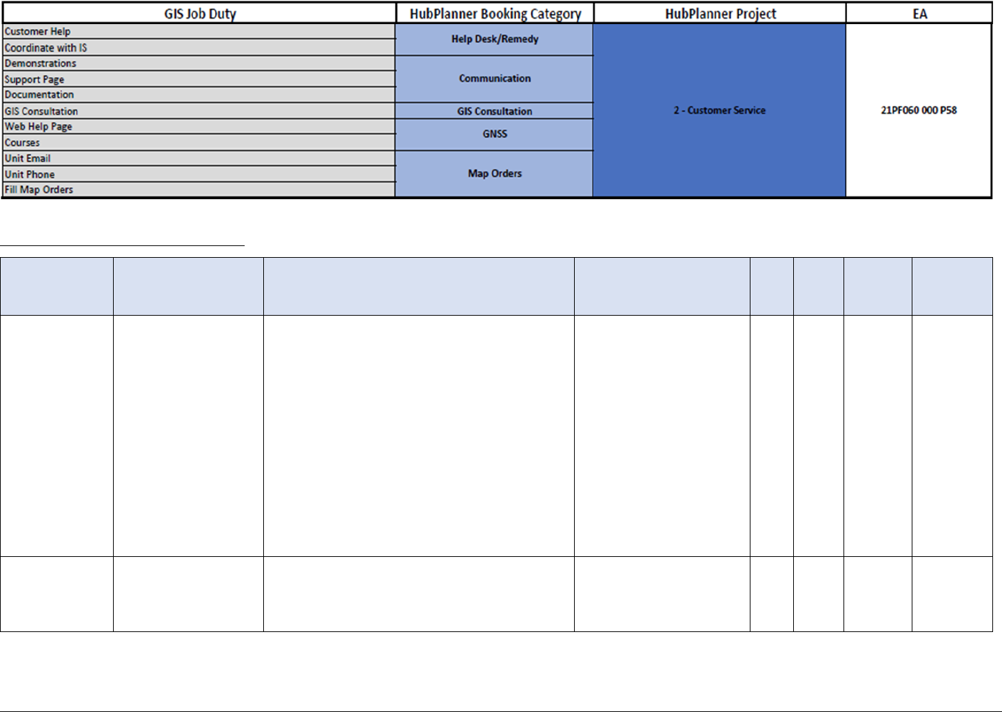
GIS Unit
Category
GIS Unit Activity
Description
Objective
Plan
Year
Quick
Win
Slimgim
Success
Factors
GIS Unit
Goals
Communication
Promote the value of
GIS Unit services
Better communicate (“Market”) the services,
resources, capabilities and vision of the GIS Unit
to agency (especially with business lines with
the biggest anticipated ROI). Need to clearly
define the core operational functions of the GIS
Unit - delineating the bounds of which with
respect to overlaps with other business units.
Update the charter/mission of the GIS Unit so
that other ODOT units know what its mission is
and what services and resources it offers. This
will help remove uncertainty and redundancies,
where they exist, to strengthen collaboration
and cooperation.
Ensure that ODOT
understands the valuable
role the GIS Unit plays in
meeting ODOT's strategic
goals and mandates.
1-5
USS,
GCF,
SPD
1a, 3, 4b
Communication
Promote the value of
spatial information
for new ODOT
initiatives
Promote the value of spatial information for
new ODOT initiatives that involve data
analytics, performance metrics, business
intelligence, or accomplishment tracking.
To ensure that ODOT fully
leverages the value of
GIS.
1-5
GPA,
VCU
1c, 4c

GIS Unit
Category
GIS Unit Activity
Description
Objective
Plan
Year
Quick
Win
Slimgim
Success
Factors
GIS Unit
Goals
Communication
Provide easier access
to data
Need an easy-to-use, centralized, authoritative
data and shared services catalogue. Deploy a
data discovery tool that provides easy access to
GIS metadata for each layer. Communicate the
availability and location of standard maps so
that staff don’t think they have to create them
on their own.
3-4
PPD,
DAI
2, 3
Documentation
Documentation
Catalog
The GIS Unit has a lot of documentation in a lot
of places. An effort to catalog and centralize the
documentation would make it easier to locate,
and more likely to be used.
Improve ease of access to
GIS Unit documentation.
1-2
SPD
2
GIS
Consultation
Create a "GIS
Business Analyst"
role
ODOT will benefit from adding a GIS staff
member (FTE or contractor) whose role and
expertise is in defining GIS project
requirements and evaluating technical
approach options in order to design an optimal
solution.
Ensure staff are properly
equipped to handle
project tasks other than
the technical work
involved.
1
AHR
5b
GIS
Consultation
Evaluate need for the
creation of a Project
Management Office
(PMO) or team
Evaluate potential need for GIS Project
Management roles in GIS Unit or a PMO that
contains GIS PM specialists to support GIS Unit
in addition to other PM needs of the agency
(not related to Preconstruction and
Construction DOT projects).
Determine the necessity
of a Project Management
Office or GIS Project
Management role.
1-2
GPA,
FGG
1
GIS
Consultation
Discover ODOT GIS
needs and identify
tools to simplify
duplicative processes.
Balance training activities: provide AGOL easy
tools vs. training in ArcMap.
Ensure GIS technology
are right sized with staff
needs. Better align
GIS tools with staff needs
to reduce training &
support demand.
1-3
EUS,
USS
3

GIS Unit
Category
GIS Unit Activity
Description
Objective
Plan
Year
Quick
Win
Slimgim
Success
Factors
GIS Unit
Goals
GIS
Consultation
Business Analysis of
Tools
Build upon inventory of GIS Tools and
Technology Audit document to conduct a
business analysis of tools - enough tools, right
tools, do they need to be more integrated, have
more consistent look and feel, are there gaps?
Round-out the
understanding of status
of technology and tools
collection.
2-5
PW1,
TBD
3a
GIS
Consultation
Include GIS standards
in ODOT
procurements
ODOT should involve GIS unit when planning,
procuring and deploying relevant technology
solutions so that best practices and standards
can be enforced from the beginning.
Strengthen the use of GIS information in ODOT
project lifecycles – from planning, through
design and construction, to ongoing operations
and maintenance.
To ensure ODOT contract
include GIS best practice
requirements and
standards.
3-5
GPA
1
Help Desk /
Remedy
Enhance GIS
awareness of help
desk staff
Work with help desk to educate them on the
GIS products, processes, capabilities, and
responsibilities to better assist help desk with
triage of questions, issues, requests, and
tickets.
Ensure that Staff are
"process-minded."
1
EEU,
SPM
3
Help Desk /
Remedy
GIS Project Request
Portal revamp
Suggest a new status for waiting on customer
feedback to account for time lag due to
customer inactivity. Suggest domained values
and other mechanisms to control freeform
content in form.
Keep active project list in
check.
1-2
SPD,
GPM,
EUS
2a, 3
GIS
Consultation
Consistent Project
Sopping,
Management, and
Delivery Practices
A consistent project scoping, management, and
delivery methodology and practice should be
developed/adopted and implemented (trained
to all staff). A lite version of that training could
also be offered to GIS Unit partners to whom
data applications and products are often
delivered.
Improve consistency,
efficiency, and outcomes
of GIS project deliveries.
1-5
GPA
1a, 1b, 4b

Infrastructure Operations
Proper GIS-IT infrastructure maintenance and operational management is at the crux of any GIS group. The GIS Unit is no different in
this regard, currently monitoring and maintaining a diverse portfolio of GIS technologies and the infrastructure that supports them for
ODOT enterprise use. The GIS Unit will continue to operate and maintain, in coordination with Information Services, the critical
infrastructure that underpins GIS success at ODOT. Over time, the GIS Unit can achieve an increasingly robust GIS technology
infrastructure by employing additional software packages to assist in the maintenance and operation of this environment. Additional
software can specifically help with editing and licensing within the environment and will assist in the rightsizing of technologies to
enterprise needs.
Infrastructure Opportunities
GIS Unit
Category
GIS Unit Activity
Description
Objective
Plan
Year
Quick
Win
Slimgim
Success
Factors
GIS Unit
Goals
Hardware
Implement Esri
ArcGIS Monitor
Implement Esri ArcGIS Monitor to quantify and
track utilization (typical and peak) for
infrastructure and architecture planning.
Ensure GIS Server
technology is properly
managed and scaled.
1
BTM,
BCC,
PW3
3

GIS Unit
Category
GIS Unit Activity
Description
Objective
Plan
Year
Quick
Win
Slimgim
Success
Factors
GIS Unit
Goals
Security
Document access
points and rules for
enterprise GIS
platform
The Enterprise application architecture must be
well mapped and accessible. Also, guidelines
and rules for new tethers (new applications or
updates dependent on GIS data - locations,
models, schemas, domains, etc.) to the
application architecture must be well
documented, known, and followed.
Improve documentation
of architecture and
security systems.
1-5
SAC, DAI
1b, 1c, 2c
Software
Management
Geomedia
Replacement
Ready to have discussion around moving out of
GeoMedia. Most of the data management is a
function of system (legacy) As-Is and not a
function of planned, best case.
Fully understand LRS
software options other
than current situation.
1-2
BDC
3
Software
Management
Licensing Level
Determination
Workflow
Currently, ODOT staff can change their own
licensing levels once installed. But in future
(when?) will have to justify both the install and
the level. (With goal to provide AGOL apps and
solutions where appropriate.) Ensure staff have
access to software licenses needed to do work
via role-based toolbox.
Improve software
licensing level process
and ensure software
licensing availability and
right-sizing.
1-2
CBC,
GRA
1b
Software
Management
Sunset ArcPad in
favor of Collector
ArcPad licenses are down from 55 to 10. Good
opportunity to work with remaining users to
replace with updated technology and phase out
its use.
Migrate mobile platform
to more modern and less
client-intensive products.
2
PW3,
USS
3a, 4c
Software
Management
ArcGIS Pro licensing
needs assessment
Asses Pro licensing needs by reviewing those of
similar agencies (such as NVDOT) who have
migrated to Enterprise and Portal.
Ensure that ArcGIS Pro
licensing is correctly
distributed and utilized.
2-3
USS
2b, 4b
Software
Management
Mirror Custom
Solutions with COTS
Solutions
Use “out of the box” (COTS) web development
technologies to re-create custom solution
functions to (1) overcome any limitations of
current custom solution (such as downloading
data from TransGIS, a desired feature heard
from many survey respondents) and/or (2)
lower overhead of maintaining custom
solutions with simpler COTS technologies.
Provide enhanced
functionality of Web GIS
solutions.
2-4
PW3,
USS
2b, 3a

Data Management & Development Operations
As data stewards and aggregators for the ODOT enterprise, the GIS Unit must remain vigilant in its handling of key aspects of data
management, to include but not limited to: curating a data inventory; making data accessible (who can access, for what purpose(s), how
to access); and helping the enterprise understand who is responsible for maintaining what data. As the GIS Unit continues a role of data
steward and aggregator for the ODOT enterprise, it will focus on making sure correct data/datasets are used for appropriate purposes,
are accessible, and are as centralized and organized as possible. Pertaining to GIS Unit internal datasets, time will be spent focusing on
data quality, ensuring data editing is standardized and documented, and data are as complete as necessary.

GIS Unit
Category
GIS Unit Activity
Description
Objective
Plan
Year
Quick
Win
Slimgim
Success
Factors
GIS Unit
Goals
Administration
AGOL and ArcGIS
Server Updates
It is worth considering proliferation of data
with consistent metadata, download
capabilities, and APIs via AGOL hosting (see
Iowa open data model in State Comparison
document).
Ensure Server technology
is properly managed and
scaled.
3
SAC
4b
Administration
Participate in Data
Management/Data
Warehouse
Committee(s) /
Group(s)
Consider establishing or participating in
existing data management committees and/or
groups at ODOT to help guide governance for
how the Agency wants to manage all data
(spatial and non-spatial) in a centralized and
standardized way.
To manage all data
(spatial and non-spatial)
in a centralized and
standardized way.
1-5
FGG
1
Administration
Data Governance
Need a holistic data governance, integration &
reporting strategy to manage data better.
Understand who, how,
why, and where data are
viewed and maintained.
3-5
DOC,
IBS
1
Documentation
Create SOP's for
common GIS tasks
Develop standard operating procedures (SOPs)
for common GIS-based ODOT workflows to
guide training.
Document the GIS Unit's
ODOT data handling
roles.
2-4
SPM,
SPD
1b, 4b
Documentation
Inter-Agency
Communication Plan
The GIS Unit serves as a data aggregator; a
communication plan formed collaboratively
with the groups that they aggregate data from
and for could be useful for better
understanding data updates and schedule.
Document the GIS Unit's
ODOT data handling
roles.
2-4
IDC
2c, 4b
Imagery
Current, High
Resolution Imagery
Many survey responses and interviewees
mentioned the need for additional reliable high
resolution imagery. The GIS Unit will
investigate the extent of this need
and investigate the up time of existing imagery
to determine if improvements could be made
there to mitigate the need for additional
imagery.
Provide reliable access to
current, high quality
basemap data.
2-5
PW4,
BDC
3b, 4b

GIS Unit
Category
GIS Unit Activity
Description
Objective
Plan
Year
Quick
Win
Slimgim
Success
Factors
GIS Unit
Goals
Updates /
Postings
LRS Consolidation
Evaluation
Evaluate potential gains from migrating to a
single LRS with one LRM and one technology
stack. A single LRS will likely facilitate access by
multiple users editing simultaneously via SDE.
Evaluate benefit of single
authoritative LRS/LRM
allowing multi-user
concurrent editing.
1
BDC
1b, 2b, 2c
Updates /
Postings
Add missing/desired
data to internal GIS
Unit catalog and
enterprise
Continue to add spatial data layers (new and
historic content). Reduce the need for staff to
access external information sources. Leverage
existing frameworks and processes (such as
Decision and Information Needs Identification
Tool from SDBP) to conduct decision-making
consistently with enterprise.
Increase quantity and
quality of internal GIS
Unit data.
1-5
PW4
2
Updates /
Postings
Enhance priority data
sets
Enhance some data layers (update, accuracy,
resolution, more content/attributes)
Increase quality and
completeness of internal
GIS Unit data.
1-5
BDC
2
Updates /
Postings
Provide data
automation tools
Deploy more tools that automate data flow
within the organization.
Improve efficiency of
data flow through the
enterprise.
1-5
NCF,
DME
2
Updates /
Postings
Implement Esri Data
Reviewer (DR)
Esri’s Data Reviewer extension is a powerful
data quality control tool. The GIS Unit’s role as
a data aggregator may limit the uses of this
tool, but in the situations where it could be
applied it would likely allow for a major
improvement in output data quality or at the
least, make performing data quality control an
easier task to navigate.
Improve data quality or
data quality reporting
capabilities.
2
FQC
2, 3a
Updates /
Postings
Establish a GIS Portal
Establish a centralized, internal portal for all
things GIS where frequent news and updates
are available for those who want (or need) to
know. As part of governance, establish high-
level process documentation standards and
leverage them to create SOPs and maintain
them in a centralized and accessible network
location (Internal GIS User Portal).
Ensure that process
documentation is
standardized and easy-
to-find (centralized).
3
DAI,
BDC
2

GIS Unit
Category
GIS Unit Activity
Description
Objective
Plan
Year
Quick
Win
Slimgim
Success
Factors
GIS Unit
Goals
Updates /
Postings
Implement Esri
Workflow Manager
(WMX)
Esri’s Workflow Manager extension can help
organize and streamline repetitive workflows
and foster repeatability in product creation and
output amongst multiple users. More
specifically, several GIS Unit staff referenced
annual or semi-annual products that must be
created. Depending on determined ROI, the
GIS Unit could implement WMX workflows to
aid in these processes, likely by offering some
automation or the ability to delegate the tasks
to other users as necessary. These automated
processes
Add automation and
consistency to workflows
and processes,
particularly for
stakeholders.
2
DME,
SPD
2b, 2c, 4c
Updates /
Postings
Automating
Promotion Sequence
Develop more efficient methods to conduct
promotion sequence using R1 jobs or other
technology.
Improve efficiency of
data and software
promotion among
environments.
3
SAC,
RIM
1b, 2b
Updates /
Postings
Centralize/consolidate
data locations
Establish a singular GIS Data Warehouse (one
that can window into other repositories as
needed as a single view for data)
Centralize data
repositories.
3-5
BDC
2
Updates /
Postings
Improve integration
between GIS and
documents
Easier access to documents (plans, as-builts,
permits, ROW docs) – link to GIS location
Improve efficiency of
accessing non-spatial
supporting documents in
a spatial system.
4-5
DIE
2c
Updates /
Postings
Project/Plan Sheet
Disseminator
This isn’t currently a space where the GIS Unit
has systems or expertise to leverage, but in the
future ODOT might consider evaluating plan
sharing technologies, or in their absence,
looking into what technological methods or
workflows are available to allow simple sharing
and download.
Increase access to
construction plans.
5
GCS,
SPD
2c

Application Support & Development Operations
The GIS Unit implements, supports, creates, documents, and/or maintains dozens of tools and technologies for ODOT enterprise use (see
GIS Unit Tools and Technology Portfolio section of this document for more details). Providing Application Support and Development
for GIS will continue to be a critical function of the GIS Unit. Moving forward, these roles will gain efficiency as processes continue to be
documented, guidance continues to be offered, and as the use and proliferation of technology is tracked, analyzed, and its use is
encouraged.

GIS Unit
Category
GIS Unit Activity
Description
Objective
Plan
Year
Quick
Win
Slimgim
Success
Factors
GIS Unit
Goals
Administration
Improve Data
Proliferation,
Interoperability, and
Integration
Two large decisions face GIS Unit that will drive
the direction of the technology stack, ELA
needs, and focus/skillsets of many staff
for the next 3-5 years: (1) Data proliferation in
cloud (AGOL) or on ODOT servers OR
combination and (2) Data Warehouse
integration – keeping the tabular and
geospatial data worlds in sync (given the
likelihood that the Data Warehouse will remain
a tabular repository).
Provide reliable access to
current, high quality data
that is easy to find, in
relatively few and
consolidated locations,
linked or referenced
between locations, and
consistent.
1-5
BDC,
DAI,
PW4
1b, 3
AGOL
AGOL Cleanup and
Governance
AGOL is heavily used with web servers for AGOL
mostly being hosted in the DMZ ArcGIS Server.
However, there remain some services
published to cloud from prior to the existence
of the DMZ ArcGIS Server. Need review and
transition of remaining cloud services to ArcGIS
Server; review of existing services on ArcGIS
Server; and governance established for AGOL.
Understand who, how,
why, and where ArcGIS
Online is being used.
2-5
RIM
1, 4b
Documentation
Provide user guides
for GIS tools
Create more/better documentation for
commonly used ODOT tools and procedures to
help reduce the technical support request load.
Develop simple, “quick start” user guides for
GIS-based tools commonly used at ODOT.
Ensure institutional
knowledge retention and
transferability.
2-5
SPD
2b, 3a
Internally
Developed &
Hosted
Applications
Leverage Data
Analytics/Business
Intelligence
Investigate best technologies and tools for GIS
data analytics and business intelligence for use
at ODOT.
Foster the growth of data
analytics and business
intelligence in the GIS
Unit.
1-2
BIG
3

GIS Unit
Category
GIS Unit Activity
Description
Objective
Plan
Year
Quick
Win
Slimgim
Success
Factors
GIS Unit
Goals
Internally
Developed &
Hosted
Applications
Provide more access
to GPS-integrated
mobile applications
for field data
collection
Mobile GIS is going to be a growing area of
needed support. This will come with a desire
for field data transactions with the enterprise.
Increase the
understanding of creating
spatial data from multiple
devices.
1-5
USS,
EUS
3a, 4b
Mapping Operations
Custom map requests in addition to many standard mapping products are a staple responsibility of the GIS Unit. Standard products
include the Official Oregon State Map, Oregon City and County Atlas series, Maintenance District Map and Oregon Transportation
Commission (OTC) Maps. Providing custom maps is also a large component of the customer service apparatus of the GIS Unit (see figure
below). Continuing to provide these mission-critical services to ODOT will become less of a burden on the GIS Unit as the requests for
such services are tracked and analyzed to determine which requests for service fall on the GIS Unit as a custom process, which requests
can be fulfilled with a templated process, and which request onus can be placed back on the requestor as a self-service web mapping task.
Mapping Opportunities
GIS Unit
Category
GIS Unit Activity
Description
Objective
Plan
Year
Quick
Win
Slimgim
Success
Factors
GIS Unit
Goals
Custom
Mapping
Identify common
map requests for web
mapping and/or map
template solutions
Track custom map requests to identify common
requests/themes that can be accommodated
via web mapping solutions or formatted into
templates for easier creation in future.
Reduce custom mapping
requests and increase
customer service for
mapping.
1-5
SPM,
NCF,
USS
3a


Training Operations
The GIS Unit currently offers training to both GIS Unit staff and other ODOT staff throughout other division offices and Districts. All
training offered are viewed as a good opportunity to bolster the strengths of the GIS Unit (internal) and for outreach (external). Adding
additional, focused training for new and existing internal GIS Unit staff and creating training offerings for external ODOT divisions
highlighting the availability of GIS tools and data will foster a stronger GIS community throughout ODOT.
Training Opportunities
GIS Unit
Category
GIS Unit Activity
Description
Objective
Plan
Year
Quick
Win
Slimgim Success
Factors
GIS Unit
Goals
Training
Given
Better communicate
training available for
GIS technology and
tools.
Easy to find and take basic training on the
tools we have (Tool-related training
catalogue).
Ensure ODOT staff are
aware of training
opportunities.
1-2
CCT, EUS, LTC
4a
Training
Given
Establish and
promote monthly
GIS "lunch & learn"
meetings.
Establish a regular (monthly?) brown bag
“lunch and learn” for GIS users to share
knowledge and ask questions.
Expand ODOT staff
training opportunities.
1-2
CCT, LTC
4a, 5c
Training
Given
New Employee
Orientation Package
and Training Plan.
Create standard new employee
orientation package to get employees up
to speed consistently with less stress on
current staff.
Improve the new
employee onboarding
process.
1-2
EUS, LTC, AHR
4a, 5a
Training
Given
Cross-training.
Cross-train GIS support staff and establish
a knowledge base so that there is not only
one person who knows something.
Ensure institutional
knowledge retention
and transferability.
1-5
GRA, BCC, CSC
4a, 5c

GIS Unit
Category
GIS Unit Activity
Description
Objective
Plan
Year
Quick
Win
Slimgim Success
Factors
GIS Unit
Goals
Training
Given
Offer "GIS Unit Boot
Camp" for new
ODOT staff.
Provide “GIS Unit Boot Camp” training for
all new relevant staff to help reduce the
technical support request load. Provide an
“Intro to GIS” class so that
new/future/beginner users have a basic
grasp of GIS Unit vocabulary and
capabilities.
Improve the new
employee onboarding
process.
2
AHR, CCT
4a, 5b
Training
Given
Clearly define GIS
training service
offerings.
Need to clearly delineate what areas of
training the GIS Unit is responsible for
(Esri tools and apps, working with
geospatial data, etc.) vs. FME or other
related topics, applications, and tools.
Expand ODOT staff
training opportunities.
2-3
LTC, CCT
4a, 4b
Training
Given
Establish a role-
based training plan.
Establish a comprehensive, role-based
training plan for ODOT staff based on job
duties and the GIS tools they need to use.
Ensure new and
current staff can
quickly identify, access,
and take GIS training
for their specific job
role/duties.
2-3
AHR, CCT, LTC
4a, 4b,
5c
Training
Given
Provide basic
training/tutorials
for. how to locate
and use GIS data
Provide training on how to search for and
use ODOT’s data. Integrate GIS into daily
workflow, not just GIS Data.
Increase the
understanding of how
to access and use
spatial data.
2-3
LTC, EUS
4a, 3a
Training
Given
Deploy more “self-
service” technical
support options.
Deploy “self-service” technical support
and training resource options that include
a GIS FAQ page, library of training videos,
user guides, knowledge base, SME contact
list, etc. Offer regular “refresher”
classes/online videos for the most
commonly used GIS-based tools at ODOT.
Allow users to help
themselves first,
before contacting GIS
Unit for assistance.
3-4
USS
4a, 2c
Training
Given
Establish a GIS User
Certification
program at ODOT.
Establish a GIS User Certification program
at ODOT to ensure that required GIS user
skills are confirmed/validated in a
standardized way.
To ensure that Core
GIS competency is
improved with training
plans.
4-5
CWC, LTC, BCC
4a, 5c

GIS Unit
Category
GIS Unit Activity
Description
Objective
Plan
Year
Quick
Win
Slimgim Success
Factors
GIS Unit
Goals
Training
Received
Risk Management
for Data-Related
Business
Identify appropriate risk management
representatives within GIS Unit to liaise
with broader enterprise data risk
management activities (committee
discussions, plans, etc.). Identify and
engage in on-going training in risk
management for data-related business.
Engage enterprise data
apparatus in risk
management activities.
1-5
IDC, GCF
5b
Training
Received
BA Training
Business Analysis training was one of the
two top requested trainings from
engagement efforts. Some requests for
this training were direct while others were
inferred by interviewers based on typical
job duties and types of challenges they
described. Given the dependence on
business analysis skillset for daily
operations, a training plan in business
analysis is highly recommended.
Cultivate business
analysis skill of the GIS
Unit to improve project
delivery outcomes such
as clear and early
requirements for a
stable project scope.
1-5
BCC, EFI, CCT, LTC,
GLA, SPM
5b
Training
Received
FME Training
Given the high use of FME across
the GIS Unit and saturation
in GIS Unit workflows and business,
a training plan for FME is highly
recommended.
Cultivate GIS
automation skills and
improve efficiency.
1-5
BCC, EFI, CCT, LTC,
SPM
5b
Training
Received
Web GIS Training
Develop standard onboarding and ongoing
training curriculum for relevant staff to
ratify training of Web GIS at ODOT
(architecture, infrastructure, publishing
services, AGOL, etc.).
Improve Web GIS
standardization and
efficiencies through
consistent training and
education.
1-5
BCC, CCT, LTC, GLA
5b
Training
Received
Data Governance
Engagement
Training
Engage in on-going training in data
governance concepts. Engage in on-going
enterprise-level data literacy training
anticipated from activities of the SDBP.
Be trained, capable,
and ready to engage in
agency data
governance initiatives.
1-5
FGG, ARD, GCS,
DOC, LTC, GLA
1,5b

GIS Unit
Category
GIS Unit Activity
Description
Objective
Plan
Year
Quick
Win
Slimgim Success
Factors
GIS Unit
Goals
Training
Received
Data Review
Technologies
Review and Training
Investigate data reviewing technologies
such as Esri Data Reviewer extension for
gains in efficiency, consistency, and
quality of review processes. On-going
training in selected technologies is
recommended to be added to workforce
development planning.
Improve data review
technologies and
practices.
2-5
GCF, LTC, SPM,
FQC
2a, 5b
Training
Received
Normal Data
Publication Cycle
Training
Review GIS data publication cycles in data
catalog noting non-scheduled and ad-hoc
publishing cycles. Identify those that could
be on a regular schedule and work with
business units toward normalized and
scheduled publication cycle.
Normalization (consistent process) and
scheduling could occur over several
iterations of engagement. An example
could be a completely ad-hoc process that
happens whenever could first get into a
quarterly publication expectation
(agreement between business unit
and GIS Unit). Though the timing
within the given quarterly month might
not be set, now only 4 of 12 months are
open to the publication process.
Normalize publication
processes and cycles
(schedules) for GIS
data improving
consistency and
predictability of data
availability, workloads,
and methods.
1-5
GCF,
LTC, FQC, DAI, DME
2, 5b
Training
Received
Master Data
Management
(MDM)
Identify GIS master data elements,
prioritize management improvement
needs, and develop and pursue MDM
Initiatives. These all would begin with GIS
Unit staff engaging in MDM training.
Establish processes and
methods to establish
authoritative sources
for “master data”
beginning with training
in MDM.
1-2
GCF,
LTC, FQC, DAI, DME
2, 5b

Appendix C: Slimgim-T Reference
This appendix provides reference information for the Slimgim-T Capability Maturity
Model (CMM).
13
Below is the template summary web chat of the Slimgim-T CMM
assessment results. Each of the corners of the web correspond to the six general areas of
maturity. The six general maturity score values are based on a composite of success
factors (as shown in the tables that follow) in each area that are scored along five levels:
1. Ad Hoc (think, act, work locally)
2. Planned / Early Stage
3. Partially Implemented
4. Enterprise
5. Optimized (think, work, act globally)
13
https://www.slimgim.info/the-method.html
Figure 24: Slimgim-T CMM Summary Web Chat Comparison

By utilizing the self-assessed maturity and likelihood by category, areas of the most
potential for change (improvement) can be of highest priority and gap analysis focus for
most likely positive results. The matrix presented below is employed for establishing a
reviewing method and priority.
Table 3: Capability Maturity Model Matrix
Likelihood
Extremely
Unlikely
Unlikely
Neutral
Likely
Extremely
Likely
Maturity
Ad-Hoc
(individual or
none)
Maturity
gains in this
space are
very unlikely.
Not explored
in this study;
however,
gaps noted
through other
review
activities will
be noted.
Maturity gains in this space
can come easily, and even
despite unlikely engagement
or support, can find success.
Gaps found through other
review activities will be
noted.
Maturity gains in this space
can come easily, especially
with engagement
anticipated by a likely self-
assessment. Gaps will be
sought and explored.
Planned / Early
Stage
(departmental)
Partially
Implemented
(corporately
but not
consistently)
Maturity in this space
requires high levels of
consistent engagement of
SMEs (unlikely/neutral). Of
less focus in this study;
however, gaps that are noted
through other review
activities will be noted.
Maturity in this space
requires high levels of
engagement of SMEs
which is likely given self-
assessment. Gaps will be
sought and explored in this
space.
Enterprise
(corporately
and
consistently)
Optimized
(corporately
and optimized)
Agency is fully mature! Innovative differences will be noted. Not of specific
focus of this study.

Following are the six general maturity areas with their component success factors and
descriptions.
1.
Organizational Structure and Leadership
GIO
1.1 GIS manager or coordinator
The organization has a permanent Enterprise GIS management function and position.
GIA
1.2 GIS is authoritative
GIS has been established by upper management as the authoritative source of spatial
data and recognized as a critical component of business systems.
FGG
1.3 Formal GIS governance
Formal GIS governance is established which may include committee structures, user
groups and working groups. Some structure is in place to coordinate long range
planning, stakeholder satisfaction and ability to leverage enterprise gis (EGIS) are in
place in some organized manner.
GRA
1.4 GIS resource allocation
Management has in place policies, procedures, and sufficient resource allocation to
maintain GIS related services.
VCU
1.5 GIS vision, comprehensive use & innovation
Management is committed to EGIS and are fostering participation of users in EGIS
activities. They have a vision and foster awareness of the benefits and encourage
innovation. Strategic plans are in place that directs comprehensive use of spatial data.
Enterprise planning processes align with EGIS strategic goals and vision.
BTM
1.6 Benefits are tracked & measured
Management measure tangible benefits of EGIS in order to track success and guide
decisions and planning.
SLB
1.7 Senior management learning
One or more representatives from top management are interested in learning how
EGIS opportunities can help realize improvements to their core business.
BCC
1.8 Enterprise GIS competency & capacity
Committed to competence and capacity building at all levels as it relates to EGIS.
IDC
1.9 Inter-department cooperation
An emphasis is placed on integration and coordination of inter-departmental
activities. There are processes and procedures in place for inter-departmental conflict
management and to prevent duplicative efforts.
AHC
1.10 Adaptable hierarchy to align with change
The organization is able to adapt to evolution and change by creating a new hierarchy
to align with the changes.
GPA
1.11 GIS Projects align with enterprise vision
GIS projects undertaken work seamlessly within the enterprise framework and aim to
help the organization work smarter and more efficiently.

2.
Corporate Culture
BUP
2.1 Business units have active EGIS participationThere is active participation and
involvement of business units in EGIS activities, implementation, planning, etc.
EFI
2.2 Environment of the organization fosters innovation
Learning, change and continuous improvement is an accepted and practiced
philosophy.
ARD
2.3 Staff accept EGIS as a reliable data source
It is generally accepted that EGIS is the authoritative, reliable source of spatial data for
the organization (system of record).
CSC
2.4 Open cross-unit cooperation & information sharing
Interaction amongst employees is open and cross-unit cooperation and sharing of
information, ideas, best practices, and inquiry is common.
AHR
2.5 Adaptable hiring practices ensure modern skills
The level of adaptability regarding the organization's ability to change hiring practices
to ensure those with both the requisite modern spatial skill set, up-to-date training and
an innovation mindset are prioritized.
CCT
2.6 Core competency improved with training plans
The corporation encourages improvement of core competency which is supported by a
comprehensive training plan.
GCF
2.7 Enterprise GIS related communication is frequent & guided by plans
A strong communication and employee engagement plan is in place & align to strategic
goals. Enterprise GIS related communication is frequent at all levels and is tailored to
staff and partners with follow up procedures to evaluate effectiveness of
communication.
EEU
2.8 Employees at all levels encouraged to use GIS
Employees at all levels think spatially and are encouraged to explore and improve their
practices by incorporating spatial data. This aligns people and process to the corporate
vision.

3.
Process Orientation
SPM
3.1 Staff are "process-minded"
Business process is valued by the organization. Staff are "process-minded" and often
are involved in business process mapping and other exercises and are capable of
interpreting and following the results.
GCS
3.2 EGIS process & goals shared across silos
Enterprise process and goals are shared among functional areas.
GPM
3.3 GIS operation align with performance management
GIS operations align with performance management.
PAS
3.4 Plan to improve & align process to strategic plan
Processes are in place for improving and aligning business to strategic plan. There is a
management commitment to improve their section to improve process.
SPD
3.5 Process documentation standardized & central
High level process documentation and task responsibilities are centralized and
accessible and the organization follows a standard methodology for business process
mapping.
DME
3.6 Data maintenance embedded in business workflow
Data maintenance procedures, including editing roles, are embedded in business
workflow and either consistently pushed out to data custodians or automated using
workflow tools or automation.
4.
Organizational Capacity and Capability
GLA
4.1 EGIS led by appropriate and sufficient staff
Enterprise GIS staff are led by a qualified manager with the appropriate GIS
education, experience, and credentials. There is sufficient staff with the appropriate
training for GIS viability. This position is within or tightly aligned with I.T. requiring
competencies with EGIS architecture, business process, relationship building,
stakeholder engagement and project management.
DIE
4.2 GIS data interoperability exists
GIS data-interoperability exists to enable integration of spatial data from various
sources within and external to the organization.
CWC
4.3 Corporate-wide spatial competency
Appropriate employees have a competency in using spatial data and
applications/systems supplied by EGIS.
NCF
4.4 GIS ‘operators’ no longer have a cartography/map making focus
A GIS / IT team has evolved and is focused on more complex automation and data
management services. Cartography, map making (includes story maps) and basic
analysis has become the common task of the end-user.

5.
Enterprise GIS Sustainability
CBC
5.1 Long term corporate budget commitment
There is a budget for long term commitments for support, licensing, etc. such as an
Enterprise License Agreement (ELA). GIS software acquisition is a coordinated effort
across departments and the EGIS budget is seen as a cost of doing business.
TBD
5.2 Balance of tech resources & data admin
Planning and controls are in place to balance technological resources with
organizational needs as well as administration of data resources and automations.
EUS
5.3 End-users well supported
End-users are well supported with online guides, training material, technical support
including service quality practices. IT staff are used for infrastructure support.
BIG
5.4 Blending of IT, analysis, visualization & GIS
There is an active partnership or blending between GIS and IT technical staff as well
as a specialization of analytical & visualization staff.
MBP
5.5 Mechanism to maintain business unit participation
Mechanisms are in place to maintain continued participation of the business units.
ESU
5.6 External support utilized
External support such as consultants and specialized contract employees can be
utilized when required to assist with activities.
LTC
5.7 Long term competency & training plans
Long term competency and training plans are in place and continue to be followed.
SDC
5.8 Spatial data is core / mission-critical
Spatial data is core to business applications and is centralized and an essential part of
work and e-services.
USS
5.9 Ubiquitous access to web self-service maps
Web based self-service GIS/Mapping tools with ubiquitous access are in place with the
list of applications continuing to grow.
PW1
5.10 Data and application backups
Data backup and security for GIS data and applications is defined, reliable, controlled
and consistent.

6.
Foundational Data and Technologies
DOC
6.1 Business unit data owners & data stewards defined
Data stewards are defined for each dataset. Business unit end-user data owners have
been identified and are involved in data maintenance, quality procedures and
decisions regarding their related datasets.
PPD
6.2 Production & published database of reliable data
There is both a centralized managed production database as well as a published
environment for consumption and distribution. The data is accessible and reliable. A
development environment exists.
SAC
6.3 System architecture current
The system architecture design is current with plans in place for future enhancements,
expansion and upgrades.
FQC
6.4 Formal QA/QC process
There is a formal QA/QC for each business process. Quality control and data accuracy
are built into editing to reduce human error.
DAI
6.5 Data common & available for integration
Spatial data is published in the organization's common data warehouse. Spatial data is
readily available for integration and interoperability.
RIM
6.6 Redundancy of information management reduced
Data duplication is minimized across the organization.
BDC
6.7 All foundation datasets modeled & centralized
The organization's enterprise data have all undergone data modeling, are centralized,
loaded, and maintained.
IBS
6.8 Direct integration to business systems
Spatial data is an integral part of business systems and direct integration has been
established.
PW2
6.9 Metadata
Metadata available and maintained for all foundational and business data layers.
PW3
6.10 Technical Infrastructure
Technical infrastructure in place to maintain and operate the GIS and to meet
organizations’ needs.
PW4
6.11 Foundational Data
Adequate foundational data and secondary data exists to meet business requirements.

Appendix D: Terms and Acronyms
The following terms may be found in this document, for additional ODOT terms and
acronym information consult the ODOT online Acronyms and Glossary.
Terms
Business Steward – A data subject matter expert who manages data in conformance with
agency policy and guidelines
Business Intelligence - A set of techniques and tools for accessing raw data from various
agency systems and transforming it into meaningful and useful information forbusiness
purposes.
Capability Maturity Model – A methodology used to define, measure, develop, and
refine an organization’s level of maturity within a particular field.
Coordinating Data Steward – A staff person that coordinates and facilitates
implementation and data governance practices
Data Analytics - Techniques for transforming data into information to provide insights
into current conditions and/or likely implications of potential future actions.
Data Governance - The formal orchestration of people, processes, and technology to
enable the organization to leverage data as an enterprise asset.
Data Management - The set of activities carried out to manage data across its life cycle –
it includes: planning, collecting/acquiring, documenting, organizing, storing, controlling,
disseminating, using and disposing of data.
Data Program - A business unit whose primary responsibilities include collection,
processing, reporting and/or distribution of a particular class of data.
Data Quality - The degree to which data is accurate, complete, timely and consistent with
requirements and business rules and relevant for a given use.
Data Set - A collection of data made available for access or download in one or more
formats. Examples: a state’s crash records for a single year; a database with roughness
measures for pavement segments on the state highway system.
Data Standard - An adopted agency requirement related to data content, structure,
format, naming conventions, definitions, accuracy levels or collection methods.
Data Trustee – A manager with decision making authority and responsibility for a data
asset

Data Visualization - Techniques for graphical representation of trends, patterns and
other information.
Enterprise Data - Data may be designated "of agency-wide or enterprise significance" if
(1)it is statewide in scope, (2)is pertinent to business needs of multiple divisions, (3)is
required to meet legal or regulatory requirements, and/or (4)is considered critical for
carrying out agency core functions or minimizing risks.
Findability - The degree to which relevant information is easy to find when needed;
findability is improved through application of metadata, taxonomies and other
organizing tools, and search technologies.
Guideline - A recommended practice to be considered for application in a given
situation.
Interoperability – The ability of computer systems of software to exchange and make
use of information.
Master Data - Data about entities such as customers, projects, facilities, organizational
units, etc. that is shared across different information systems.
Metadata - Data describing context, content, and structure of documents and records
and the management of such documents and records through time. Literally, data about
data.
Sensitive Data - Data that is confidential, privileged, or proprietary that should be
protected from unauthorized disclosure, loss, misuse, or corruption in order to avoid
serious consequences to the organization that owns it.
Shared Data - Data that serves the decision making needs of more than one ODOT
business unit and/or is made available for external agency use.
System Steward – A person (staff or manager) that acts as the primary administrator
for a system, platform or application asset
System Trustee – A manager with decision making authority and responsibility for a
system, platform, or application asset
Technical Data Steward – A technical staff person (typically but not always within the
information systems branch) who understands and manages how data is physically
structured and stored

GIS Unit Acronyms
AASHTO – American Association of State Highway Transportation Officials
AGOL – ArcGIS Online (Esri)
ALB – Agency Leadership Board
API – Application Programming Interface
ARNOLD – All Roads Network of Linear Referenced Data
ASIS – Aggregate Site Index System
BA – Business Analyst
CAD – Computer Aided Design
CHAMPS – Central Highway Approach Maintenance Permit System
CMM – Capability Maturity Model
COTS – Commercial Off the Shelf
DMZ – IT “demilitarized zone” (also referred to as perimeter network or screened
subnet)
DOT – Department of Transportation
DR – Data Reviewer (Esri)
EGIS – Enterprise Geographic Information System
ELA – Enterprise Licensing Agreement
ETL – Extract Translate Load
FACS – Features Attributes and Conditions Survey
FAHP – Federal Aid Highway Program
FAQ – Frequently Asked Question
FGDB – File GeoDatabase
FIT – Framework Implementation Team
FME – Feature Manipulation Engine
FTE – Full Time Employee
GDOT – Georgia Department of Transportation
GIS – Geographic Information System
GISSC – GIS Steering Committee (ODOT)

GIS-T – Geographic Information System for Transportation
GPL –GIS Program Leaders (State of Oregon)
GPS – Global Positioning System
ISC – Implementation Steering Committee
IT – Information Technology
LiDAR – Light Detection and Ranging
LRM – Linear Referencing Method
LRS – Linear Referencing System
MIRE – Model Inventory of Roadway Elements
ODOT – Oregon Department of Transportation
ODS – Open Data Standard (ORS 276A.350-374)
OGIC – Oregon Geographic Information Council
OPMA – Oregon Project Management Associate
OTC – Oregon Transportation Commission
OTSDE – Oregon Transportation Safety Data Explorer
PM – Project Management
PMF – Performance Management Frameworks
PMO – Project Management Office
QA/QC – Quality Assurance & Quality Control
RES/RAZ Map – Resource & Restricted Activity Zones (ODOT)
RICS – Road Inventory and Classification Services
ROI – Return on Investment
ROW – Right of Way
SDBP – Strategic Data Business Plan
SDE – Spatial Database Engine (Esri)
SDLC – Software Development Life Cycle
SME – Subject Matter Expert
SOP – Standard Operating Procedure
SPIS – Safety Priority Index System

SQL – Structured Query Language
STIP – Statewide Transportation Improvement Program
TAD - Transportation Application Development
TDSC – Transportation Data Steering Committee
TPOD – Transportation Planning Online Database
TRB – Transportation Research Board
USDOT – United States Department of Transportation
WashDOT – Washington State Department of Transportation
WMX – Workflow Manager (Esri)

Appendix E: Tables and Figures
Table 1: GIS Unit Staffing Levels ............................................................................................. 23
Table 2: NHTSA Model Performance Measures for State Traffic Records Systems - Roadway
Database Model Performance Measures ....................................................................................... 30
Table 4: Capability Maturity Model Matrix ................................................................................ 80
Figure 1: Policy, Data and Analysis Division Org Chart ....................................................... 4
Figure 2: GIS Unit Team Photo 2020 ......................................................................................... 4
Figure 3: SDBP Strategic Framework Elements adopted by GIS Business Plan ................. 8
Figure 4: GIS-FTE Staffing Evaluation Table (USDOT) ........................................................ 14
Figure 5: Idaho 2016 GIS Strategic Plan: Goal, Objective, Strategy alignment example . 15
Figure 6 - Summary on GIS survey responses ....................................................................... 16
Figure 7 – The level of ODOT GIS stakeholder agreement (in % of survey respondents)
with various characteristics of ODOT's current GIS. ............................................................ 17
Figure 8: Tools and Technology Audit Example ................................................................... 19
Figure 9: Esri Learning Plans.................................................................................................... 25
Figure 10: Iowa DOT example of posting GIS Unit roles ..................................................... 26
Figure 11: Workforce Development Theme & Recommendation Example ...................... 28
Figure 12: SDBP Strategic Framework Elements ................................................................... 38
Figure 13: Official Oregon State Map ...................................................................................... 47
Figure 14: ODOT TransGIS ....................................................................................................... 50
Figure 15: ODOT GIS Project Requests ................................................................................... 51
Figure 16: Oregon Transportation Safety Data Explorer (OTSDE) ..................................... 52
Figure 17: LiDAR at ODOT ...................................................................................................... 53
Figure 18: Geometronics Online Toolkit ................................................................................. 54
Figure 19: Esri Survey 123 ......................................................................................................... 55
Figure 20: FME Data Transformation Workflow .................................................................. 56
Figure 21: ODOT Geoportal ..................................................................................................... 57
Figure 22: GIS Project Request Form ....................................................................................... 57

